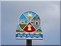
IMAGES TAKEN NEAR TO
Broadfield, DUNMOW, CM6 1NY
Introduction
This page details the photographs taken nearby to Broadfield, CM6 1NY by members of the Geograph project.
The Geograph project started in 2005 with the aim of publishing, organising and preserving representative images for every square kilometre of Great Britain, Ireland and the Isle of Man.

There are currently over 7.5m images from over14,400 individuals and you can help contribute to the project by visiting https://www.geograph.org.uk
Image Map
Images are licensed for reuse under creativecommons.org/licenses/by-sa/2.0
Notes
- Clicking on the map will re-center to the selected point.
- The higher the marker number, the further away the image location is from the centre of the postcode.
Image Listing (12 Images Found)
Images are licensed for reuse under creativecommons.org/licenses/by-sa/2.0
Image
Details
Distance
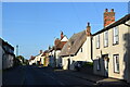
1
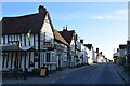
The Black Lion and the view north east along The Street
The Black Lion proclaims itself "a Traditional 14th Century Coaching Inn" (no doubt correctly).
Image: © Trevor Harris
Taken: 28 May 2022
0.09 miles
3
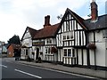
The Black Lion, High Roding
The core of the structure is C15 but with many later additions. See http://www.britishlistedbuildings.co.uk/en-352755-the-black-lion-public-house-high-roothin#.VhrMn_lViko for entry in British Listed Buildings.
Image: © Bikeboy
Taken: 3 Oct 2015
0.10 miles
7
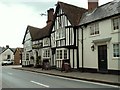
'The Black Lion' inn, High Roding, Essex
This inn dates back to the 14th century. It stands on an old Roman road which is now the B184.
Image: © Robert Edwards
Taken: 17 Apr 2006
0.12 miles
8
Pargeted house, High Roding
One of the less attractive buildings along The Street were it not for the fact that it displays rather a lot of pargeting.
Image: © Robin Webster
Taken: 8 Sep 2011
0.12 miles
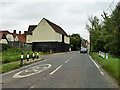
9
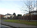
High Roding
A view from he northern end of the village. The early morning sun highlights the little thatched cottage. High Roding is very much a linear settlement with very little development back from The Street - which follows the line of a Roman Road. Some modern development has resulted in some "back streets".
Image: © Trevor Harris
Taken: 28 May 2022
0.14 miles
10
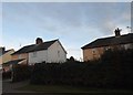
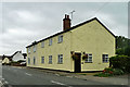
Ware Farm, High Roding
The first buildings in the village of High Roding, a very picturesque ribbon development along the old Roman road.
Image: © Robin Webster
Taken: 8 Sep 2011
0.16 miles