IMAGES TAKEN NEAR TO
The Street, DUNMOW, CM6 1NW
Introduction
This page details the photographs taken nearby to The Street, CM6 1NW by members of the Geograph project.
The Geograph project started in 2005 with the aim of publishing, organising and preserving representative images for every square kilometre of Great Britain, Ireland and the Isle of Man.

There are currently over 7.5m images from over14,400 individuals and you can help contribute to the project by visiting https://www.geograph.org.uk
Image Map
Images are licensed for reuse under creativecommons.org/licenses/by-sa/2.0
Notes
- Clicking on the map will re-center to the selected point.
- The higher the marker number, the further away the image location is from the centre of the postcode.
Image Listing (14 Images Found)
Images are licensed for reuse under creativecommons.org/licenses/by-sa/2.0
Image
Details
Distance
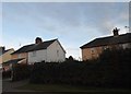
1
Rosemary Cottages, High Roding, Essex.
Image: © Derek Voller
Taken: 25 Jun 2009
0.01 miles
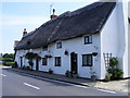
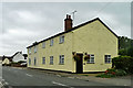
2
The Old Lamb, High Roding
It seems to have been converted to residential use. See http://www.britishlistedbuildings.co.uk/en-352794-the-old-lamb-public-house-high-roothing-#.VhrOavlViko for entry in British Listed Buildings
Image: © Bikeboy
Taken: 3 Oct 2015
0.03 miles
3
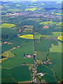
High Roding from the air
The north end of the village, with the cricket pitch visible on the right. Great Dunmow is visible in the distance.
Image: © Thomas Nugent
Taken: 9 May 2011
0.05 miles
4
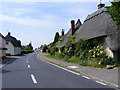
The B184 through High Roding, Essex
High Roding, Pretty village situated one third of the way along the ancient Roman road from London to Bury St Edmunds in Suffolk.
Image: © Derek Voller
Taken: 25 Jun 2009
0.09 miles
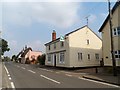
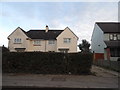
6
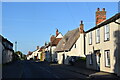
High Roding
A view from he northern end of the village. The early morning sun highlights the little thatched cottage. High Roding is very much a linear settlement with very little development back from The Street - which follows the line of a Roman Road. Some modern development has resulted in some "back streets".
Image: © Trevor Harris
Taken: 28 May 2022
0.12 miles
7
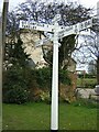
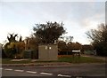
Direction Sign ? Signpost on the B184 in High Roding village
Located on the east side of the crossroads of the B184 Dunmow Road, Canfield Road and Rands Road, High Roding. In High Roothing parish. 4 arms and half-moon finial.
Milestone Society National ID: EX_TL6017
Image: © John V Nicholls
Taken: Unknown
0.14 miles
9
Pargeted house, High Roding
One of the less attractive buildings along The Street were it not for the fact that it displays rather a lot of pargeting.
Image: © Robin Webster
Taken: 8 Sep 2011
0.16 miles