IMAGES TAKEN NEAR TO
Dunmow Road, DUNMOW, CM6 1NL
Introduction
This page details the photographs taken nearby to Dunmow Road, CM6 1NL by members of the Geograph project.
The Geograph project started in 2005 with the aim of publishing, organising and preserving representative images for every square kilometre of Great Britain, Ireland and the Isle of Man.

There are currently over 7.5m images from over14,400 individuals and you can help contribute to the project by visiting https://www.geograph.org.uk
Image Map
Images are licensed for reuse under creativecommons.org/licenses/by-sa/2.0
Notes
- Clicking on the map will re-center to the selected point.
- The higher the marker number, the further away the image location is from the centre of the postcode.
Image Listing (2 Images Found)
Images are licensed for reuse under creativecommons.org/licenses/by-sa/2.0
Image
Details
Distance
1
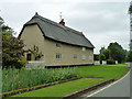
Thatched house with pargeting, Rands Road
The front face has great deal of this decorative plaster work, a speciality of this area.
Image: © Robin Webster
Taken: 8 Sep 2011
0.23 miles
2
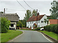
Buildings on Rands Road, High Roding
The white building is Rands Cottage, a six bedroom residence now, which originated as several cottages. Opposite is a thatched barn in the immediate surrounds of Rands, a big house out of sight to the left. The barn presents a featureless face to the road, so it is hard to tell if it is now a residence, but it is clear that it has no agricultural role.
Image: © Robin Webster
Taken: 8 Sep 2011
0.24 miles