IMAGES TAKEN NEAR TO
Chelmsford Road, DUNMOW, CM6 1LP
Introduction
This page details the photographs taken nearby to Chelmsford Road, CM6 1LP by members of the Geograph project.
The Geograph project started in 2005 with the aim of publishing, organising and preserving representative images for every square kilometre of Great Britain, Ireland and the Isle of Man.

There are currently over 7.5m images from over14,400 individuals and you can help contribute to the project by visiting https://www.geograph.org.uk
Image Map
Images are licensed for reuse under creativecommons.org/licenses/by-sa/2.0
Notes
- Clicking on the map will re-center to the selected point.
- The higher the marker number, the further away the image location is from the centre of the postcode.
Image Listing (7 Images Found)
Images are licensed for reuse under creativecommons.org/licenses/by-sa/2.0
Image
Details
Distance
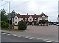
2
Broadgroves Farm, Barnston, Essex
The road in this picture is the A.130 leading to Great Dunmow. This part actually follows the course of a Roman Road.
Image: © Robert Edwards
Taken: 18 Aug 2006
0.15 miles
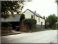
3
High Easter Road, Barnston
A country road with quite a lot of modern residential development feeding into it from the left.
Image: © Robin Webster
Taken: 8 Sep 2011
0.21 miles
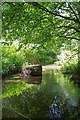
5

A120 Chelmer bridge - graffiti
As is usual with structures with large expanses of bare concrete, unofficial adornment soon appears.
Image: © Robin Webster
Taken: 7 Jun 2016
0.24 miles
6
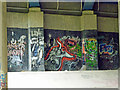
A120 Chelmer bridge - graffiti
As is usual with structures with large expanses of bare concrete, unofficial adornment soon appears.
Image: © Robin Webster
Taken: 7 Jun 2016
0.24 miles
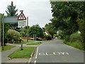
7
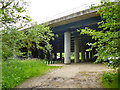
A120 bridge over River Chelmer
Particularly wide, as four lanes of dual carriageway and also two slip roads cross the river. The bridge also crosses a public byway, used by National Cycle Route 16.
Image: © Robin Webster
Taken: 7 Jun 2016
0.25 miles