IMAGES TAKEN NEAR TO
Bacon End, DUNMOW, CM6 1JW
Introduction
This page details the photographs taken nearby to Bacon End, CM6 1JW by members of the Geograph project.
The Geograph project started in 2005 with the aim of publishing, organising and preserving representative images for every square kilometre of Great Britain, Ireland and the Isle of Man.

There are currently over 7.5m images from over14,400 individuals and you can help contribute to the project by visiting https://www.geograph.org.uk
Image Map
Images are licensed for reuse under creativecommons.org/licenses/by-sa/2.0
Notes
- Clicking on the map will re-center to the selected point.
- The higher the marker number, the further away the image location is from the centre of the postcode.
Image Listing (4 Images Found)
Images are licensed for reuse under creativecommons.org/licenses/by-sa/2.0
Image
Details
Distance
1
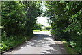
Road junction at Bacon End
Close to Bacon End Farm.
Image: © Trevor Harris
Taken: 11 Jun 2022
0.06 miles
2
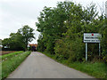
Entering Bacon End
The sign ahead on the left warns of possible flooding. When this happens it would appear to be caused by poor drainage rather than any natural watercourse overflowing.
Image: © Robin Webster
Taken: 8 Sep 2011
0.08 miles
3
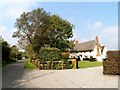
Bacon End Cottages
Originally built around 1300 but with much alteration since. See http://www.britishlistedbuildings.co.uk/en-352660-bacon-end-cottages-great-canfield-essex#.Vls4YnbhDIU for entry in British Listed Buildings.
Image: © Bikeboy
Taken: 3 Oct 2015
0.10 miles
4
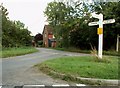
Road junction at Bacon End, Essex
Bacon End lies east of Great Canfield. The house in the picture belongs to Bacons Farm.
Image: © Robert Edwards
Taken: 1 Sep 2006
0.10 miles