IMAGES TAKEN NEAR TO
Philpot End, DUNMOW, CM6 1JQ
Introduction
This page details the photographs taken nearby to Philpot End, CM6 1JQ by members of the Geograph project.
The Geograph project started in 2005 with the aim of publishing, organising and preserving representative images for every square kilometre of Great Britain, Ireland and the Isle of Man.

There are currently over 7.5m images from over14,400 individuals and you can help contribute to the project by visiting https://www.geograph.org.uk
Image Map
Images are licensed for reuse under creativecommons.org/licenses/by-sa/2.0
Notes
- Clicking on the map will re-center to the selected point.
- The higher the marker number, the further away the image location is from the centre of the postcode.
Image Listing (6 Images Found)
Images are licensed for reuse under creativecommons.org/licenses/by-sa/2.0
Image
Details
Distance
2
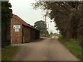
Philpot End Lane, near Great Dunmow, Essex
The picture shows a farm building that is part of Puttocks Farm.
Image: © Robert Edwards
Taken: 15 Sep 2006
0.17 miles
3
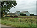
Barns at Puttocks Farm
Judging by the pile of crates, this farm grows something other than cereals, which tend to dominate this area.
Image: © Robin Webster
Taken: 8 Sep 2011
0.18 miles
5
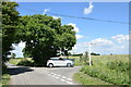
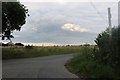
Lane junction near Puttock
I am standing in Philpot End Lane which continues ahead; to the right is Mountains Farm Road.
Image: © Trevor Harris
Taken: 11 Jun 2022
0.20 miles
6
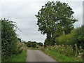
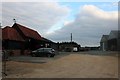
Philpot End Lane
Although undoubtedly a way to Philpot End, the End itself is down Dove Lane.
Image: © Robin Webster
Taken: 8 Sep 2011
0.24 miles