IMAGES TAKEN NEAR TO
Clapton Hall Lane, DUNMOW, CM6 1JE
Introduction
This page details the photographs taken nearby to Clapton Hall Lane, CM6 1JE by members of the Geograph project.
The Geograph project started in 2005 with the aim of publishing, organising and preserving representative images for every square kilometre of Great Britain, Ireland and the Isle of Man.

There are currently over 7.5m images from over14,400 individuals and you can help contribute to the project by visiting https://www.geograph.org.uk
Image Map
Images are licensed for reuse under creativecommons.org/licenses/by-sa/2.0
Notes
- Clicking on the map will re-center to the selected point.
- The higher the marker number, the further away the image location is from the centre of the postcode.
Image Listing (13 Images Found)
Images are licensed for reuse under creativecommons.org/licenses/by-sa/2.0
Image
Details
Distance
1
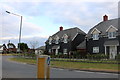
New houses on Ongar Road, Great Dunmow
This was an open field until not long ago.
Image: © David Howard
Taken: 13 Jul 2019
0.06 miles
2
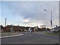
Roundabout on Ongar Road, Great Dunmow
Image: © David Howard
Taken: 19 Nov 2017
0.06 miles
4
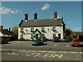
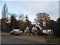
'The Kicking Dickey' public house, Great Dunmow, Essex
This pub was formerly known as 'The Railway Tavern'. It's on the road to Ongar.
Image: © Robert Edwards
Taken: 5 Apr 2006
0.14 miles
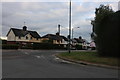
6
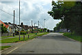
Ongar Road at the junction of Chelmsford Road
Image: © David Howard
Taken: 19 Nov 2017
0.21 miles
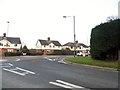
7
Chelmsford Road at the junction of Ongar Road
Image: © David Howard
Taken: 13 Jul 2019
0.22 miles
8
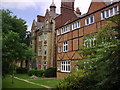
Buckingham Court, The Close, Great Dunmow.
Buckingham Court today converted into residential flats.
Formerly a workhouse and prisoner of war camp.
Image: © Cliff Law
Taken: 22 Jun 2009
0.23 miles
9
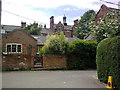
The Close, Great Dunmow
The Close, now a residential area, formerly a workhouse incorporating hospital, stables, blacksmiths. Later used as a prisoner of war camp in WWII. One of the first workhouses to be converted into residential accommodation.
Image: © Cliff Law
Taken: 22 Jun 2009
0.23 miles
10
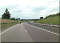
A120 overbridge carries B184
The B184 is also Ongar Road.
Image: © Stuart Logan
Taken: 23 Jun 2013
0.24 miles