IMAGES TAKEN NEAR TO
Hubberd Road, DUNMOW, CM6 1GW
Introduction
This page details the photographs taken nearby to Hubberd Road, CM6 1GW by members of the Geograph project.
The Geograph project started in 2005 with the aim of publishing, organising and preserving representative images for every square kilometre of Great Britain, Ireland and the Isle of Man.

There are currently over 7.5m images from over14,400 individuals and you can help contribute to the project by visiting https://www.geograph.org.uk
Image Map
Images are licensed for reuse under creativecommons.org/licenses/by-sa/2.0
Notes
- Clicking on the map will re-center to the selected point.
- The higher the marker number, the further away the image location is from the centre of the postcode.
Image Listing (37 Images Found)
Images are licensed for reuse under creativecommons.org/licenses/by-sa/2.0
Image
Details
Distance
1
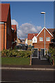
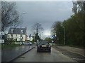
Hubbard Road
Viewed from Dunmow Road.
Image: © Thomas Nugent
Taken: 10 Feb 2010
0.03 miles
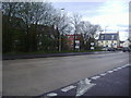
2
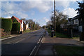
Dunmow Road
Looking east from Roding Drive roundabout.
Image: © Thomas Nugent
Taken: 10 Feb 2010
0.04 miles
3
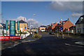
Roding Drive
A new housing development off Dunmow Road.
Image: © Thomas Nugent
Taken: 10 Feb 2010
0.07 miles
4
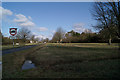
Field at Smiths Green Road
At the corner of Dunmow Road.
Image: © Thomas Nugent
Taken: 10 Feb 2010
0.08 miles
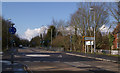
5
The junction of Dunmow Road and Roding Drive
Roding Drive is the entrance to the new Priors Green village based on their version of medieval cottages. A matter of taste I suppose, but to me extremely bad taste.
Image: © David Howard
Taken: 25 Apr 2012
0.09 miles
6
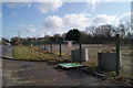
Gap site
A brownfield site on Dunmow Road.
Image: © Thomas Nugent
Taken: 10 Feb 2010
0.10 miles
7

Post box on Dunmow Road
Near to Smiths Green Road.
Image: © Thomas Nugent
Taken: 10 Feb 2010
0.10 miles
8
New houses on Priors Green, Takeley
Priors Green is described as a new village, and will leave the viewers to make their own opinions.
Image: © David Howard
Taken: 25 Apr 2012
0.11 miles
9
Dunmow Road
A fairly new roundabout at the junction with Canfield Road, which is to the left.
Image: © Thomas Nugent
Taken: 10 Feb 2010
0.12 miles
10
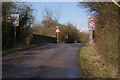
Old railway bridge
Crosses the disused railway line that is now The Flitch Way footpath at Canfield Road.
Image: © Thomas Nugent
Taken: 10 Feb 2010
0.12 miles