IMAGES TAKEN NEAR TO
Cannons Lane, ONGAR, CM5 0TG
Introduction
This page details the photographs taken nearby to Cannons Lane, CM5 0TG by members of the Geograph project.
The Geograph project started in 2005 with the aim of publishing, organising and preserving representative images for every square kilometre of Great Britain, Ireland and the Isle of Man.

There are currently over 7.5m images from over14,400 individuals and you can help contribute to the project by visiting https://www.geograph.org.uk
Image Map
Images are licensed for reuse under creativecommons.org/licenses/by-sa/2.0
Notes
- Clicking on the map will re-center to the selected point.
- The higher the marker number, the further away the image location is from the centre of the postcode.
Image Listing (11 Images Found)
Images are licensed for reuse under creativecommons.org/licenses/by-sa/2.0
Image
Details
Distance
1
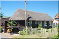
The Essex Way 27: Thatched Caravan
This thatched caravan is beside the footpath as it enters Cannon's Green. A unique dwelling?
Image: © Trevor Harris
Taken: 23 May 2010
0.03 miles
2

Bridleway Near Cannon's Green
This bridleway is PROW 191_34 it ends up at Image
Image: © Glyn Baker
Taken: 16 May 2020
0.06 miles
3
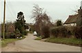
An area of Fyfield known as Cannon's Green
The picture shows the end of Cannons Lane
Image: © Robert Edwards
Taken: 22 Feb 2008
0.06 miles
4

Cannon Green
Lane adopted by the Essex Way long distance footpath, running through the hamlet of Cannon Green
Image: © Chris Heaton
Taken: 2 Oct 2018
0.06 miles
5

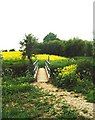
Fork in The Bridleway
Bridleway 191_50 bears left and 191_34 is to the right.
Image: © Glyn Baker
Taken: 16 May 2020
0.14 miles
6

Linking Footpath, Canon's Green
This footpath leads south from Canon's Green - linking with the Essex Way and the Three Forests Way
Image: © John Winfield
Taken: 31 May 2006
0.18 miles
7
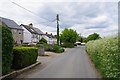
Cannon's Lane Fyfield
Looking back towards the village.
Image: © Glyn Baker
Taken: 16 May 2020
0.23 miles
8
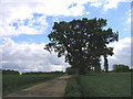
Track leading to airstrip
The 1940 OS map shows this location as being at the edge of a large woodland area (Witney Woods). However most of it seems to have disappeared in the last 60 years.
Image: © John Winfield
Taken: 31 May 2006
0.23 miles
9

Essex Way heading towards Cannon's Green
Image: © Chris Heaton
Taken: 2 Oct 2018
0.24 miles
10
Tun Bridge, near Fyfield
The bridge spans the River Roding.
Image: © David Kemp
Taken: 3 May 2007
0.25 miles