IMAGES TAKEN NEAR TO
Dunmow Road, ONGAR, CM5 0NR
Introduction
This page details the photographs taken nearby to Dunmow Road, CM5 0NR by members of the Geograph project.
The Geograph project started in 2005 with the aim of publishing, organising and preserving representative images for every square kilometre of Great Britain, Ireland and the Isle of Man.

There are currently over 7.5m images from over14,400 individuals and you can help contribute to the project by visiting https://www.geograph.org.uk
Image Map
Images are licensed for reuse under creativecommons.org/licenses/by-sa/2.0
Notes
- Clicking on the map will re-center to the selected point.
- The higher the marker number, the further away the image location is from the centre of the postcode.
Image Listing (6 Images Found)
Images are licensed for reuse under creativecommons.org/licenses/by-sa/2.0
Image
Details
Distance
1
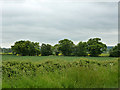
Hedgerow trees
On the boundary of Abbess, Beauchamp and Berners Roding amalgamated parish and Fyfield parish.
Image: © Robin Webster
Taken: 11 Jun 2013
0.11 miles
2
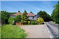
B184 at Rose Cottage
A byway called Image starts here on the left.
Image: © Glyn Baker
Taken: 28 May 2020
0.12 miles
3
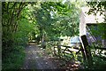
Perryfield Lane
Image: © Glyn Baker
Taken: 28 May 2020
0.15 miles
4
Byway PROW 191_21
This Public Right OF Way is a byway called Image
Image: © Glyn Baker
Taken: 28 May 2020
0.16 miles
5
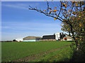
Butt Hatch Farm, near Fyfield, Essex
Located on west side of Dunmow Road just north of Fyfield
Image: © John Winfield
Taken: 14 Nov 2005
0.22 miles
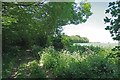
6
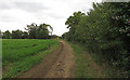
Footpath on field margin near Butt Hatch Farm, Beauchamp Roding
Image: © Roger Jones
Taken: 28 Jun 2020
0.25 miles