IMAGES TAKEN NEAR TO
Fyfield Road, ONGAR, CM5 0HH
Introduction
This page details the photographs taken nearby to Fyfield Road, CM5 0HH by members of the Geograph project.
The Geograph project started in 2005 with the aim of publishing, organising and preserving representative images for every square kilometre of Great Britain, Ireland and the Isle of Man.

There are currently over 7.5m images from over14,400 individuals and you can help contribute to the project by visiting https://www.geograph.org.uk
Image Map
Images are licensed for reuse under creativecommons.org/licenses/by-sa/2.0
Notes
- Clicking on the map will re-center to the selected point.
- The higher the marker number, the further away the image location is from the centre of the postcode.
Image Listing (36 Images Found)
Images are licensed for reuse under creativecommons.org/licenses/by-sa/2.0
Image
Details
Distance


8
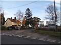
The entrance to Fyfield Business and Research Park
Image: © David Howard
Taken: 19 Nov 2017
0.02 miles
9
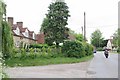
The Start of Chursh Lane
At the junction with Fifield Rd B184
Image: © Glyn Baker
Taken: 16 May 2020
0.02 miles
10
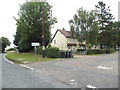
Service Road off Fyfield Road, Shelley
It leads to a research centre
Image: © David Howard
Taken: 20 Aug 2017
0.02 miles