IMAGES TAKEN NEAR TO
Willingale Road, ONGAR, CM5 0FE
Introduction
This page details the photographs taken nearby to Willingale Road, CM5 0FE by members of the Geograph project.
The Geograph project started in 2005 with the aim of publishing, organising and preserving representative images for every square kilometre of Great Britain, Ireland and the Isle of Man.

There are currently over 7.5m images from over14,400 individuals and you can help contribute to the project by visiting https://www.geograph.org.uk
Image Map
Images are licensed for reuse under creativecommons.org/licenses/by-sa/2.0
Notes
- Clicking on the map will re-center to the selected point.
- The higher the marker number, the further away the image location is from the centre of the postcode.
Image Listing (68 Images Found)
Images are licensed for reuse under creativecommons.org/licenses/by-sa/2.0
Image
Details
Distance
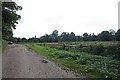
3
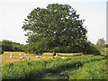
Sheep & tree in field near Ponders Lodge, Fyfield
Image: © Roger Jones
Taken: 23 Jun 2020
0.08 miles
4
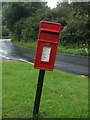
Elizabeth II postbox, Fyfield
Postbox No. CM5 62.
See Image] for context.
Image: © JThomas
Taken: 5 Aug 2017
0.10 miles
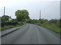
5
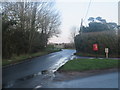
Willingale Road, Fyfield
A view of Willingale Road in the Essex village of Fyfield.
Willingale Road is on the route of National Cycle Network route 1.
Image: © Malc McDonald
Taken: 18 Jan 2020
0.10 miles
6
Dunmow Road, Fyfield
Looking north east on the B184.
Image: © JThomas
Taken: 5 Aug 2017
0.11 miles