IMAGES TAKEN NEAR TO
Wind Hill, ONGAR, CM5 0EX
Introduction
This page details the photographs taken nearby to Wind Hill, CM5 0EX by members of the Geograph project.
The Geograph project started in 2005 with the aim of publishing, organising and preserving representative images for every square kilometre of Great Britain, Ireland and the Isle of Man.

There are currently over 7.5m images from over14,400 individuals and you can help contribute to the project by visiting https://www.geograph.org.uk
Image Map
Images are licensed for reuse under creativecommons.org/licenses/by-sa/2.0
Notes
- Clicking on the map will re-center to the selected point.
- The higher the marker number, the further away the image location is from the centre of the postcode.
Image Listing (5 Images Found)
Images are licensed for reuse under creativecommons.org/licenses/by-sa/2.0
Image
Details
Distance
1
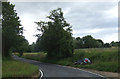
Bad piece of parking
Car in ditch on a bend, Wind Hill. Hopefully they will be able to learn a lesson.
Image: © JThomas
Taken: 5 Aug 2017
0.04 miles
2
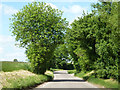
Wind Hill
The name of the lane, as a hill not amounting to much.
Image: © Robin Webster
Taken: 5 Jun 2013
0.07 miles
3
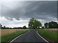
Heading north, Wind Hill
Just before a storm.
Image: © JThomas
Taken: 5 Aug 2017
0.10 miles
4
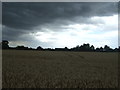
Cereal crop north west of Moreton
Just before a storm.
Image: © JThomas
Taken: 5 Aug 2017
0.12 miles
5
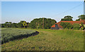
Arable field boundary near Ashlings Cottages, Magdalen Laver
Image: © Roger Jones
Taken: 30 May 2020
0.17 miles