IMAGES TAKEN NEAR TO
Magdalen Laver, ONGAR, CM5 0EH
Introduction
This page details the photographs taken nearby to CM5 0EH by members of the Geograph project.
The Geograph project started in 2005 with the aim of publishing, organising and preserving representative images for every square kilometre of Great Britain, Ireland and the Isle of Man.

There are currently over 7.5m images from over14,400 individuals and you can help contribute to the project by visiting https://www.geograph.org.uk
Image Map
Images are licensed for reuse under creativecommons.org/licenses/by-sa/2.0
Notes
- Clicking on the map will re-center to the selected point.
- The higher the marker number, the further away the image location is from the centre of the postcode.
Image Listing (13 Images Found)
Images are licensed for reuse under creativecommons.org/licenses/by-sa/2.0
Image
Details
Distance
3
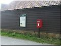
Elizabeth II postbox, Humphreys
Postbox No. CM5 38.
See Image] for close up.
Image: © JThomas
Taken: 5 Aug 2017
0.03 miles
4
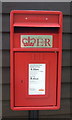
Close up, Elizabeth II postbox, Humphreys
Postbox No. CM5 38.
See Image] for wider view.
Image: © JThomas
Taken: 5 Aug 2017
0.03 miles
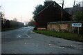
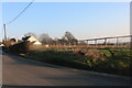
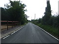
6
The road to Greens Farm and Strawberry Hall
Image: © Robert Edwards
Taken: 14 Apr 2008
0.07 miles
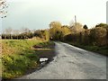
8
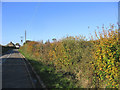
Autumnal Hedge - Magdalen Laver, Essex
A view to the west in Hastingwood Lane
Image: © John Winfield
Taken: 17 Nov 2005
0.13 miles