IMAGES TAKEN NEAR TO
Mill Lane, ONGAR, CM5 0DN
Introduction
This page details the photographs taken nearby to Mill Lane, CM5 0DN by members of the Geograph project.
The Geograph project started in 2005 with the aim of publishing, organising and preserving representative images for every square kilometre of Great Britain, Ireland and the Isle of Man.

There are currently over 7.5m images from over14,400 individuals and you can help contribute to the project by visiting https://www.geograph.org.uk
Image Map
Images are licensed for reuse under creativecommons.org/licenses/by-sa/2.0
Notes
- Clicking on the map will re-center to the selected point.
- The higher the marker number, the further away the image location is from the centre of the postcode.
Image Listing (11 Images Found)
Images are licensed for reuse under creativecommons.org/licenses/by-sa/2.0
Image
Details
Distance
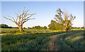
1
Arable field margin near Agrii, Moreton
Image: © Roger Jones
Taken: 30 May 2020
0.11 miles
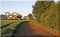
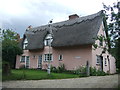
2
A view of Poppin House along Mill Lane
Image: © Robert Edwards
Taken: 11 Apr 2008
0.15 miles
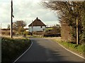
3
Mill Lane, Moreton
Taken from the road junction by Crispins.
Image: © Trevor Harris
Taken: 25 Jan 2019
0.17 miles
4
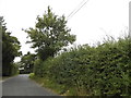
Tree on field boundary near Poppin House, Moreton
Image: © Roger Jones
Taken: 30 May 2020
0.17 miles
6
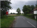
Mill Lane
Looking north on National Cycle Route 1 showing position of Postbox No. CM5 40.
See Image] for postbox.
Image: © JThomas
Taken: 5 Aug 2017
0.22 miles
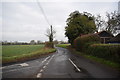
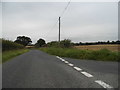
7
The end of Mill Lane as it joins Harlow Road
Image: © Robert Edwards
Taken: 11 Apr 2008
0.23 miles
8
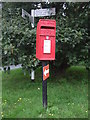
Elizabeth II postbox on Mill Lane
Postbox No. CM5 40.
See Image] for context.
Image: © JThomas
Taken: 5 Aug 2017
0.23 miles
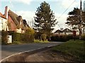
10
Mill Lane at the end of Tilegate Road
Image: © David Howard
Taken: 20 Aug 2017
0.24 miles