IMAGES TAKEN NEAR TO
Orton Close, INGATESTONE, CM4 9JN
Introduction
This page details the photographs taken nearby to Orton Close, CM4 9JN by members of the Geograph project.
The Geograph project started in 2005 with the aim of publishing, organising and preserving representative images for every square kilometre of Great Britain, Ireland and the Isle of Man.

There are currently over 7.5m images from over14,400 individuals and you can help contribute to the project by visiting https://www.geograph.org.uk
Image Map
Images are licensed for reuse under creativecommons.org/licenses/by-sa/2.0
Notes
- Clicking on the map will re-center to the selected point.
- The higher the marker number, the further away the image location is from the centre of the postcode.
Image Listing (30 Images Found)
Images are licensed for reuse under creativecommons.org/licenses/by-sa/2.0
Image
Details
Distance
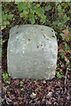
1
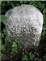
Old Milestone by Maldon Road, Margaretting parish
Carved stone post by the UC road, in parish of MARGARETTING (CHELMSFORD District), Maldon Road, by gate to public footpath, in hedge, South side of road. Erected by an unknown authority in the 19th century.
Inscription reads:-
LONDON
(??)
Grade II listed.
List Entry Number: 1392079 https://historicengland.org.uk/listing/the-list/list-entry/1392079
Milestone Society National ID: EX_MGMN25.
Image: © JV Nicholls
Taken: 25 Feb 2011
0.06 miles
2
To London 25
Old cast iron milepost at Margaretting, Essex. For overall view see http://www.geograph.org.uk/photo/4312982
Image: © Keith Evans
Taken: 11 Dec 2014
0.06 miles
3
Old Cast Iron Milepost
Old cast iron milepost at Margaretting, Essex. For close up view see http://www.geograph.org.uk/photo/4312978
Image: © Keith Evans
Taken: 11 Dec 2014
0.06 miles
5
Old Milestone
Old milestone at Margaretting, Essex for close up view see http://www.geograph.org.uk/photo/4312965
Image: © Keith Evans
Taken: 11 Dec 2014
0.07 miles
6
Old Milestone
Old milestone at Margaretting, Essex for over all view see http://www.geograph.org.uk/photo/4312970
Image: © Keith Evans
Taken: 11 Dec 2014
0.07 miles
7
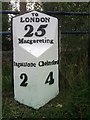
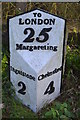
Old Milestone by the B1002, Margaretting parish
Metal plate attached to stone post by the B1002 (was A12), in parish of MARGARETTING (CHELMSFORD District), opposite the Spread Eagle PH (now modern housing), on bank above road, on South side of road. Erected by the Essex Second District turnpike trust in the 19th century.
Inscription reads:-
: Ingatstone / 2 : : TO / LONDON / 25 / Margareting : : Chelmsford / 4 :
Grade II listed.
List Entry Number: 1392080 https://historicengland.org.uk/listing/the-list/list-entry/1392080
Milestone Society National ID: EX_BWCH25.
Image: © JV Nicholls
Taken: 25 Feb 2011
0.07 miles
8
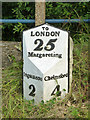
Old milepost, Margaretting
On the old main road to London, a Roman route although not very straight in this area. Nevertheless straight enough, as placing Chelmsford at 29 miles from London compares well with the railway's 29.75 miles from Chelmsford station to Liverpool Street. The current A12 is longer because of bypassing. Note how the spelling deviates from current practice: a 't' dropped in Margaretting, an 'e' dropped in Ingatestone. Either a true record, or bad spelling, or perhaps the pattern maker was just pushed for space.
Image: © Robin Webster
Taken: 28 Jul 2012
0.07 miles
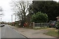
9
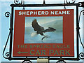
Spread Eagle inn sign
The remarkable thing about this 2012 view is that the pub, actually on the other side of the road, was burnt out some years ago and has now been demolished, with the site up for sale. There were two more inn signs in the more usual portrait format on and by the pub, but with the same portrayal of a Sea Eagle.
Image: © Robin Webster
Taken: 28 Jul 2012
0.07 miles
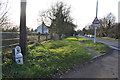
10
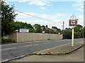
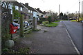
Site of Spread Eagle pub
Burnt out in 2009, still a burnt-out shell in 2011, but now demolished and the site is for sale with permission for residential development. Remarkably, the inn sign on this side of the road survives.
Image: © Robin Webster
Taken: 28 Jul 2012
0.09 miles