IMAGES TAKEN NEAR TO
The Belvoir, INGATESTONE, CM4 9HQ
Introduction
This page details the photographs taken nearby to The Belvoir, CM4 9HQ by members of the Geograph project.
The Geograph project started in 2005 with the aim of publishing, organising and preserving representative images for every square kilometre of Great Britain, Ireland and the Isle of Man.

There are currently over 7.5m images from over14,400 individuals and you can help contribute to the project by visiting https://www.geograph.org.uk
Image Map
Images are licensed for reuse under creativecommons.org/licenses/by-sa/2.0
Notes
- Clicking on the map will re-center to the selected point.
- The higher the marker number, the further away the image location is from the centre of the postcode.
Image Listing (10 Images Found)
Images are licensed for reuse under creativecommons.org/licenses/by-sa/2.0
Image
Details
Distance
1
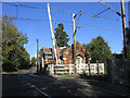
Level-Crossing Keepers Lodge, Ingatestone
Located close by Ingatestone Station, this lodge is a relic of a bygone age. In the 10 minutes I was at this location the automatic level crossing closed four time for high-speed trains on the Great Eastern line.
Image: © John Winfield
Taken: 20 Oct 2005
0.18 miles
2
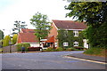
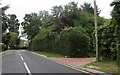
Road junction, Ingatestone
Station Road leads off to the left for the station and Ingatestone Hall.
Image: © Trevor Harris
Taken: 21 Jun 2010
0.19 miles
3
Fingerpost, junction of High St & Station Lane, Ingatestone
Cast iron fingerpost
Milestone Society National ID: EX_TQ6499
Image: © Paul Jones
Taken: 24 Oct 2020
0.19 miles
4
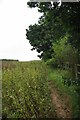
Footpath by the A12
The Image follows the fence, the A12 roars by a few feet behind the trees.
Image: © Glyn Baker
Taken: 13 Aug 2012
0.24 miles
5
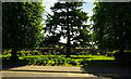
Ginge Petre almshouses (1840)
Tudor Revival Grade II listed almshouses, described in detail at this http://list.english-heritage.org.uk/resultsingle.aspx?uid=1279606
Image: © Jim Osley
Taken: 4 Jun 2013
0.24 miles
6

Ginge Petre almshouses (1840)
Tudor Revival Grade II listed almshouses.
Image: © Jim Osley
Taken: 4 Jun 2013
0.24 miles
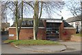
7
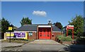
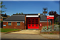
Ingatestone Fire Station
On High Street (B1002).
Image: © JThomas
Taken: 26 Aug 2022
0.24 miles
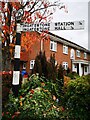
9
Ingatestone fire station
Ingatestone fire station, High Street, Ingatestone, Essex
Image: © Kevin Hale
Taken: 25 Nov 2007
0.25 miles