IMAGES TAKEN NEAR TO
High Street, INGATESTONE, CM4 9EE
Introduction
This page details the photographs taken nearby to High Street, CM4 9EE by members of the Geograph project.
The Geograph project started in 2005 with the aim of publishing, organising and preserving representative images for every square kilometre of Great Britain, Ireland and the Isle of Man.

There are currently over 7.5m images from over14,400 individuals and you can help contribute to the project by visiting https://www.geograph.org.uk
Image Map
Images are licensed for reuse under creativecommons.org/licenses/by-sa/2.0
Notes
- Clicking on the map will re-center to the selected point.
- The higher the marker number, the further away the image location is from the centre of the postcode.
Image Listing (65 Images Found)
Images are licensed for reuse under creativecommons.org/licenses/by-sa/2.0
Image
Details
Distance
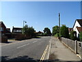
1
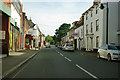
High Street, Ingatestone
The Roman road to Chelmsford and Colchester.
Image: © Robin Webster
Taken: 15 Sep 2011
0.02 miles
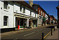
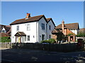
2
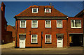
Pair of cottages, High Street, Ingatestone
Pair of 18th century Grade II listed attached cottages, described at this http://list.english-heritage.org.uk/resultsingle.aspx?uid=1197292
Image: © Jim Osley
Taken: 4 Jun 2013
0.02 miles
4
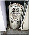
Cast iron mile post between 74 & 76 High Street Ingatestone
In need of a re-paint.
Milestone Society National ID: EX_BWCH23
Image: © Paul Jones
Taken: 24 Oct 2020
0.05 miles
7
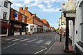
High Street, Ingatestone
Looking across the cross roads at the heart of the village.
Image: © Trevor Harris
Taken: 21 Jun 2010
0.07 miles
10
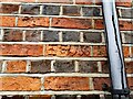
Boundary mark, inscribed brick - IF 1736
Located on the left flank wall of no. 64 High Street Ingatestone.
Milestone Society National ID: EX_INGA01pb
Image: © Paul Jones
Taken: 1 Nov 2020
0.10 miles