IMAGES TAKEN NEAR TO
The Leas, INGATESTONE, CM4 9AF
Introduction
This page details the photographs taken nearby to The Leas, CM4 9AF by members of the Geograph project.
The Geograph project started in 2005 with the aim of publishing, organising and preserving representative images for every square kilometre of Great Britain, Ireland and the Isle of Man.

There are currently over 7.5m images from over14,400 individuals and you can help contribute to the project by visiting https://www.geograph.org.uk
Image Map
Images are licensed for reuse under creativecommons.org/licenses/by-sa/2.0
Notes
- Clicking on the map will re-center to the selected point.
- The higher the marker number, the further away the image location is from the centre of the postcode.
Image Listing (12 Images Found)
Images are licensed for reuse under creativecommons.org/licenses/by-sa/2.0
Image
Details
Distance
1
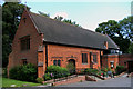
St John the Evangelist and St Erconwald RC Church, Ingatestone, Essex
Image: © Peter Stack
Taken: 11 Aug 2009
0.05 miles
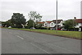
2
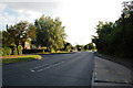
Ingatestone High Street
Looking south west along the main road from close by the RC church.
Image: © Trevor Harris
Taken: 21 Jun 2010
0.09 miles
5
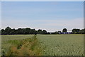
Footpath near Heybridge
Taken on the path between Ingatestone Hall and Heybridge shortly before crossing the railway. Crossing a field of wheat.
Image: © Trevor Harris
Taken: 1 Jun 2011
0.12 miles
6
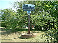
Village Sign, Ingatestone
This village sign for the Millennium has a plaque which says it was funded by local residents and businesses.
Image: © Robin Lucas
Taken: 30 Apr 2007
0.13 miles
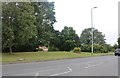
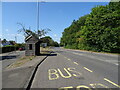
8
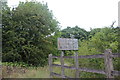
No tipping, Heybridge
It's not pre-Worboys, just worn. Why anyone should be authorised to tip in woodlands like these is anyone's guess.
Image: © David Howard
Taken: 4 Jul 2020
0.15 miles
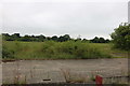
9
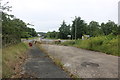
Mysterious driveway in Heybridge
Were it not for a no unauthorised tipping sign (in a wood, no less), there would be little clues as to this (now disused) little stretch of roadway.
Image: © David Howard
Taken: 4 Jul 2020
0.16 miles