IMAGES TAKEN NEAR TO
Nine Ashes Road, INGATESTONE, CM4 0QT
Introduction
This page details the photographs taken nearby to Nine Ashes Road, CM4 0QT by members of the Geograph project.
The Geograph project started in 2005 with the aim of publishing, organising and preserving representative images for every square kilometre of Great Britain, Ireland and the Isle of Man.

There are currently over 7.5m images from over14,400 individuals and you can help contribute to the project by visiting https://www.geograph.org.uk
Image Map
Images are licensed for reuse under creativecommons.org/licenses/by-sa/2.0
Notes
- Clicking on the map will re-center to the selected point.
- The higher the marker number, the further away the image location is from the centre of the postcode.
Image Listing (2 Images Found)
Images are licensed for reuse under creativecommons.org/licenses/by-sa/2.0
Image
Details
Distance
1
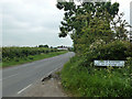
Parish of Blackmore - Hook End and Wyatts Green
At the boundary with High Ongar parish on Nine Ashes Road.
Image: © Robin Webster
Taken: 11 Jun 2013
0.10 miles
2
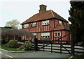
The farmhouse at Wells Farm
This lovely house stands along Redrose Lane.
Image: © Robert Edwards
Taken: 22 Feb 2008
0.19 miles