IMAGES TAKEN NEAR TO
Nine Ashes Road, INGATESTONE, CM4 0JY
Introduction
This page details the photographs taken nearby to Nine Ashes Road, CM4 0JY by members of the Geograph project.
The Geograph project started in 2005 with the aim of publishing, organising and preserving representative images for every square kilometre of Great Britain, Ireland and the Isle of Man.

There are currently over 7.5m images from over14,400 individuals and you can help contribute to the project by visiting https://www.geograph.org.uk
Image Map
Images are licensed for reuse under creativecommons.org/licenses/by-sa/2.0
Notes
- Clicking on the map will re-center to the selected point.
- The higher the marker number, the further away the image location is from the centre of the postcode.
Image Listing (15 Images Found)
Images are licensed for reuse under creativecommons.org/licenses/by-sa/2.0
Image
Details
Distance
1
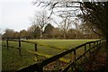
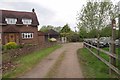
Paslow Wood Common
As seen from Nine Ashes Road. The sign reads "Paslow Common Farm" which is down the lane on the left.
Image: © Trevor Harris
Taken: 23 Jul 2009
0.04 miles
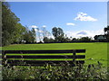
2
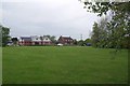
The Green at Parslow Wood Common
Looking across towards Nine Ashes Rd
Image: © Glyn Baker
Taken: 8 May 2015
0.04 miles
3
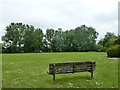
Green, Paslow Wood Common
By Nine Ashes Road.
Image: © Robin Webster
Taken: 11 Jun 2013
0.05 miles
4
St Peters Way in Parslow Wood Common
Heading towards High Ongar on the St Peters Way long distance path http://www.ldwa.org.uk/ldp/members/show_path.php?path_name=St+Peter%27s+Way
Image: © Glyn Baker
Taken: 8 May 2015
0.06 miles
5
Paslow Wood Common, Stondon Massey, Essex
Image: © John Winfield
Taken: 20 Oct 2005
0.08 miles
6
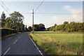
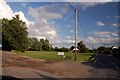
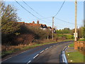
Nine Ashes Road at Paslow Wood Common
From the northern end of the common looking north along the road towards Nine Ashes.
Image: © Trevor Harris
Taken: 23 Jul 2009
0.08 miles
7
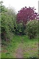
Red Tree by St Peter's Way
Looking towards High Ongar on the long distance path http://www.ldwa.org.uk/ldp/members/show_path.php?path_name=St+Peter%27s+Way
Image: © Glyn Baker
Taken: 8 May 2015
0.09 miles
8
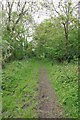
Verdant Bridleway
Part of the St Peter's Way http://www.ldwa.org.uk/ldp/members/show_path.php?path_name=St+Peter%27s+Way (Well at least according to my old map and the waymarks along the path!) The electronic map shows it following a more southerly route.
Image: © Glyn Baker
Taken: 8 May 2015
0.14 miles
9
Nine Ashes Road, near Ongar
Nine Ashes Road passing through the small hamlet of Nine Ashes, near Ongar.
This image was taken on a chilly but very sunny January afternoon. Trees were bare, the sun was low in the sky and shadows were long.
Image: © Malc McDonald
Taken: 18 Jan 2020
0.16 miles