IMAGES TAKEN NEAR TO
Wantz Road, INGATESTONE, CM4 0EP
Introduction
This page details the photographs taken nearby to Wantz Road, CM4 0EP by members of the Geograph project.
The Geograph project started in 2005 with the aim of publishing, organising and preserving representative images for every square kilometre of Great Britain, Ireland and the Isle of Man.

There are currently over 7.5m images from over14,400 individuals and you can help contribute to the project by visiting https://www.geograph.org.uk
Image Map
Images are licensed for reuse under creativecommons.org/licenses/by-sa/2.0
Notes
- Clicking on the map will re-center to the selected point.
- The higher the marker number, the further away the image location is from the centre of the postcode.
Image Listing (40 Images Found)
Images are licensed for reuse under creativecommons.org/licenses/by-sa/2.0
Image
Details
Distance
2
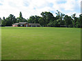
Margaretting Village Hall
The sports field in front of the hall is set up for both soccer and cricket.
Image: © John Allan
Taken: 19 Jun 2008
0.05 miles
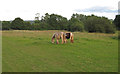
4
Public footpath through pasture with ponies, Margaretting
For a closer look at the ponies see: Image]
Image: © Roger Jones
Taken: 11 Jun 2017
0.12 miles
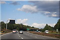
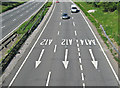
7

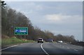
Wantz Road bridge over A12
The A12 has three lanes here to cope with the junction with the A414 (Chelmsford) junction
Image: © David Smith
Taken: 14 Jun 2014
0.13 miles
8
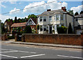
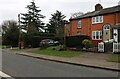
Houses in Margaretting
Alongside the B1002, the route of the old London Road.
Image: © Andrew Hill
Taken: 16 Jun 2009
0.14 miles
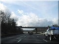
9
The A12 at Margaretting
The name Margaretting derives from Margaret's Ing (meadow). The meadow is now cut by a busy dual carriageway.
Image: © John Allan
Taken: 19 Jun 2008
0.14 miles
10
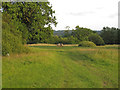
Ponies in Pasture, Margaretting
Taken from public footpath.
Image: © Roger Jones
Taken: 11 Jun 2017
0.14 miles