IMAGES TAKEN NEAR TO
High Street, INGATESTONE, CM4 0DX
Introduction
This page details the photographs taken nearby to High Street, CM4 0DX by members of the Geograph project.
The Geograph project started in 2005 with the aim of publishing, organising and preserving representative images for every square kilometre of Great Britain, Ireland and the Isle of Man.

There are currently over 7.5m images from over14,400 individuals and you can help contribute to the project by visiting https://www.geograph.org.uk
Image Map
Images are licensed for reuse under creativecommons.org/licenses/by-sa/2.0
Notes
- Clicking on the map will re-center to the selected point.
- The higher the marker number, the further away the image location is from the centre of the postcode.
Image Listing (19 Images Found)
Images are licensed for reuse under creativecommons.org/licenses/by-sa/2.0
Image
Details
Distance
1
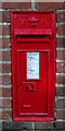
Victorian postbox on High Street (B1002), Ingatestone
Postbox No. CM4 68.
Image: © JThomas
Taken: 26 Aug 2022
0.07 miles
2
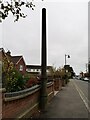
Stink pipe, High Street Ingatestone
Pre-cast concrete.
Image: © Paul Jones
Taken: 24 Oct 2020
0.07 miles
3
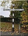
Fingerpost, junction of High Street & Docklands Avenue, Ingatestone
Cast iron fingerpost, good condition.
Milestone Society National ID: EX_TQ6599
Image: © Paul Jones
Taken: 24 Oct 2020
0.07 miles
8
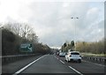
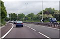
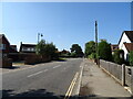
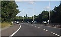
Entrance to Ingatestone, Essex
Looking west along the old A12 towards Ingatestone
Image: © John Winfield
Taken: 20 Oct 2005
0.14 miles