IMAGES TAKEN NEAR TO
Woodham Ferrers, CHELMSFORD, CM3 8RX
Introduction
This page details the photographs taken nearby to CM3 8RX by members of the Geograph project.
The Geograph project started in 2005 with the aim of publishing, organising and preserving representative images for every square kilometre of Great Britain, Ireland and the Isle of Man.

There are currently over 7.5m images from over14,400 individuals and you can help contribute to the project by visiting https://www.geograph.org.uk
Image Map (Loading...)


Getting Data...Please wait
Leaflet Map data © OpenStreetMap
Images are licensed for reuse under creativecommons.org/licenses/by-sa/2.0
Notes
- Clicking on the map will re-center to the selected point.
- The higher the marker number, the further away the image location is from the centre of the postcode.
Image Listing (6 Images Found)
Images are licensed for reuse under creativecommons.org/licenses/by-sa/2.0
Image
Details
Distance
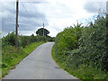
2
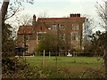
A view of Edwin's Hall from Edwin's Hall Road
This is a fragment of a much larger house that said to have built by Edwin Sandys, Archbishop of York, in the 16th century. It is still surrounded by its original moat.
Image: © Robert Edwards
Taken: 7 Apr 2008
0.10 miles
3
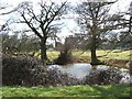
Edwin's Pond
This pond is in the grounds of Edwin’s Hall Woodham Ferrers. The hall visible behind the trees is a moated Tudor manor house. The pond appears not to be part of the moat.
Image: © Glyn Baker
Taken: 28 Feb 2006
0.15 miles
5
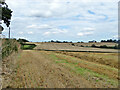
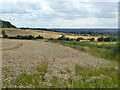
Fields south of Edwin's Hall Road
Looking east.
Image: © Robin Webster
Taken: 4 Aug 2017
0.19 miles