IMAGES TAKEN NEAR TO
Crows Lane, CHELMSFORD, CM3 8RT
Introduction
This page details the photographs taken nearby to Crows Lane, CM3 8RT by members of the Geograph project.
The Geograph project started in 2005 with the aim of publishing, organising and preserving representative images for every square kilometre of Great Britain, Ireland and the Isle of Man.

There are currently over 7.5m images from over14,400 individuals and you can help contribute to the project by visiting https://www.geograph.org.uk
Image Map
Images are licensed for reuse under creativecommons.org/licenses/by-sa/2.0
Notes
- Clicking on the map will re-center to the selected point.
- The higher the marker number, the further away the image location is from the centre of the postcode.
Image Listing (4 Images Found)
Images are licensed for reuse under creativecommons.org/licenses/by-sa/2.0
Image
Details
Distance
2
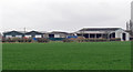
Charity Farm buildings
Viewed over arable land.
Image: © Roger Jones
Taken: 17 Mar 2012
0.17 miles
3
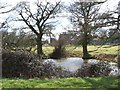
Edwin's Pond
This pond is in the grounds of Edwin’s Hall Woodham Ferrers. The hall visible behind the trees is a moated Tudor manor house. The pond appears not to be part of the moat.
Image: © Glyn Baker
Taken: 28 Feb 2006
0.22 miles
4
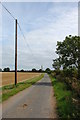
Lane east of Charity Farm
It seems that farms with this name are not uncommon though I do not know the derivation.
Image: © Trevor Harris
Taken: 29 Aug 2014
0.24 miles