IMAGES TAKEN NEAR TO
Ormonds Crescent, CHELMSFORD, CM3 8RL
Introduction
This page details the photographs taken nearby to Ormonds Crescent, CM3 8RL by members of the Geograph project.
The Geograph project started in 2005 with the aim of publishing, organising and preserving representative images for every square kilometre of Great Britain, Ireland and the Isle of Man.

There are currently over 7.5m images from over14,400 individuals and you can help contribute to the project by visiting https://www.geograph.org.uk
Image Map (Loading...)


Getting Data...Please wait
Leaflet Map data © OpenStreetMap
Images are licensed for reuse under creativecommons.org/licenses/by-sa/2.0
Notes
- Clicking on the map will re-center to the selected point.
- The higher the marker number, the further away the image location is from the centre of the postcode.
Image Listing (7 Images Found)
Images are licensed for reuse under creativecommons.org/licenses/by-sa/2.0
Image
Details
Distance
1
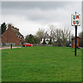
Woodham Ferrers Village Sign
Village sign on the Greensward, near housing.
Image: © Roger Jones
Taken: 17 Mar 2012
0.02 miles
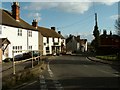
3
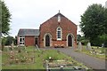
The Chapel and schoolroom, Woodham Ferrers
Image: © David Howard
Taken: 4 Jul 2020
0.11 miles
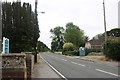
5
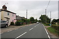
Part of Woodham Ferrers village
The road is the B1418 and it is called Main Road at this point.
Image: © Robert Edwards
Taken: 21 Mar 2008
0.18 miles
6
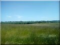
View across meadows towards Woodham Ferrers
A view from the grassland meadows of RHS Hyde Hall looking towards the village of Woodham Ferrers.
Image: © Adrian Benn
Taken: 27 May 2022
0.24 miles