IMAGES TAKEN NEAR TO
Creephedge Lane, CHELMSFORD, CM3 8RB
Introduction
This page details the photographs taken nearby to Creephedge Lane, CM3 8RB by members of the Geograph project.
The Geograph project started in 2005 with the aim of publishing, organising and preserving representative images for every square kilometre of Great Britain, Ireland and the Isle of Man.

There are currently over 7.5m images from over14,400 individuals and you can help contribute to the project by visiting https://www.geograph.org.uk
Image Map (Loading...)


Getting Data...Please wait
Leaflet Map data © OpenStreetMap
Images are licensed for reuse under creativecommons.org/licenses/by-sa/2.0
Notes
- Clicking on the map will re-center to the selected point.
- The higher the marker number, the further away the image location is from the centre of the postcode.
Image Listing (7 Images Found)
Images are licensed for reuse under creativecommons.org/licenses/by-sa/2.0
Image
Details
Distance
1
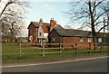
A view of Ilgar's Manor from Ilgar's Farm
Image: © Robert Edwards
Taken: 21 Mar 2008
0.06 miles
2
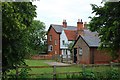
Ilgar's Manor
Taken from Creephedge Lane.
Image: © Trevor Harris
Taken: 9 Jun 2009
0.07 miles
3
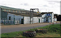
Billericay Farm Services; Fertiliser Works
Image: © Roger Jones
Taken: 29 Oct 2011
0.12 miles
4
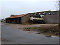
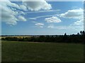
Ilgar's Farm
This is Ilgar’s Farm on Creephedge Lane
Image: © Glyn Baker
Taken: 19 Feb 2006
0.13 miles
5
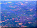
South Woodham Ferrers from the air
With the River Crouch beyond. Viewed from a Prague bound flight from Heathrow.
Image: © Thomas Nugent
Taken: 10 Apr 2011
0.14 miles
7
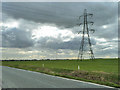
National Grid route ZT
The nearest pylon is ZT 78.
Image: © Robin Webster
Taken: 4 Mar 2014
0.24 miles