IMAGES TAKEN NEAR TO
Middlemead, CHELMSFORD, CM3 8HP
Introduction
This page details the photographs taken nearby to Middlemead, CM3 8HP by members of the Geograph project.
The Geograph project started in 2005 with the aim of publishing, organising and preserving representative images for every square kilometre of Great Britain, Ireland and the Isle of Man.

There are currently over 7.5m images from over14,400 individuals and you can help contribute to the project by visiting https://www.geograph.org.uk
Image Map (Loading...)


Getting Data...Please wait
Leaflet Map data © OpenStreetMap
Images are licensed for reuse under creativecommons.org/licenses/by-sa/2.0
Notes
- Clicking on the map will re-center to the selected point.
- The higher the marker number, the further away the image location is from the centre of the postcode.
Image Listing (22 Images Found)
Images are licensed for reuse under creativecommons.org/licenses/by-sa/2.0
Image
Details
Distance
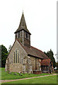
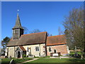
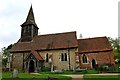
2
St Peter's, South Hanningfield
As seen from Middlemead, the road which skirts Hanningfield Reservoir.
Image: © Bill Boaden
Taken: 2 Sep 2019
0.04 miles
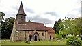
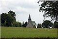
4
The Church of St Peter at South Hanningfield
Viewed from the south.
Image: © Peter Wood
Taken: 23 Feb 2015
0.04 miles
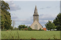
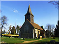
5
St Peter's Church, South Hanningfield
Taken from the road between the church and the reservoir.
Image: © Trevor Harris
Taken: 6 Jun 2009
0.04 miles

7
St Peter's Church
South Hanningfield
Image: © Julieanne Savage
Taken: 11 Feb 2008
0.05 miles
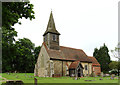
8
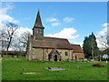
South Hanningfield church
St. Peter's.
Image: © Robin Webster
Taken: 4 Mar 2014
0.05 miles
9
St. Peter, South Hanningfield
At the end of a very narrow Church Lane
Image: © John Myers
Taken: 8 May 2012
0.05 miles