IMAGES TAKEN NEAR TO
South Hanningfield Road, CHELMSFORD, CM3 8HD
Introduction
This page details the photographs taken nearby to South Hanningfield Road, CM3 8HD by members of the Geograph project.
The Geograph project started in 2005 with the aim of publishing, organising and preserving representative images for every square kilometre of Great Britain, Ireland and the Isle of Man.

There are currently over 7.5m images from over14,400 individuals and you can help contribute to the project by visiting https://www.geograph.org.uk
Image Map (Loading...)


Getting Data...Please wait
Leaflet Map data © OpenStreetMap
Images are licensed for reuse under creativecommons.org/licenses/by-sa/2.0
Notes
- Clicking on the map will re-center to the selected point.
- The higher the marker number, the further away the image location is from the centre of the postcode.
Image Listing (15 Images Found)
Images are licensed for reuse under creativecommons.org/licenses/by-sa/2.0
Image
Details
Distance
1
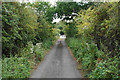
Ridge Mount
A private access track carrying a bridleway.
Image: © Bill Boaden
Taken: 2 Sep 2019
0.03 miles
2
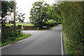
South Hanningfield Road
A lot of the local facilities relate to equestrianism.
Image: © Bill Boaden
Taken: 2 Sep 2019
0.10 miles
3
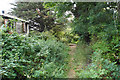
Track near Ridge Mount
The undergrowth has narrowed this route so that it is only the width of a footpath.
Image: © Bill Boaden
Taken: 2 Sep 2019
0.11 miles
4
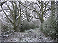
Tile Works Lane (Bridleway section), Rettendon Common
Looking North East (Towards Bromley Lodge/Morlands Industrial Estate) on the Bridleway only section of Tile Works Lane. Taken in 2008.
Image: © James Bridges
Taken: 6 Apr 2008
0.13 miles
5
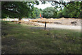
Excavation near Hunters Lodge
This will be new equestrian facilities.
Image: © Bill Boaden
Taken: 2 Sep 2019
0.13 miles
6
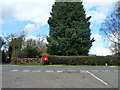
Postbox at the junction
Chalk Street meets South Hanningfield Road, where there is a rather scarce design of postbox. I think it is called a type L.
Image: © Robin Webster
Taken: 4 Mar 2014
0.14 miles
7
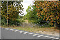
Field entrance off South Hanningfield Road
A public footpath leaves the road here, but it doesn't go through this gate. It runs to the right instead. There is a heavily laden horse chestnut tree on the right.
Image: © Bill Boaden
Taken: 2 Sep 2019
0.14 miles
8
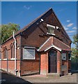
Bethel Tabernacle, South Hanningfield Road
Image: © Jim Osley
Taken: 26 Aug 2016
0.15 miles
9

Bromley Lodge
Bromley Lodge is now derelict and unsafe
Image: © Glyn Baker
Taken: 5 Apr 2008
0.20 miles
10
Bromley Lodge
The Rear of Bromley Lodge, taken in late 2004/early 2005
Image: © James Bridges
Taken: 1 Dec 2004
0.21 miles