IMAGES TAKEN NEAR TO
Warren Road, CHELMSFORD, CM3 8DG
Introduction
This page details the photographs taken nearby to Warren Road, CM3 8DG by members of the Geograph project.
The Geograph project started in 2005 with the aim of publishing, organising and preserving representative images for every square kilometre of Great Britain, Ireland and the Isle of Man.

There are currently over 7.5m images from over14,400 individuals and you can help contribute to the project by visiting https://www.geograph.org.uk
Image Map
Images are licensed for reuse under creativecommons.org/licenses/by-sa/2.0
Notes
- Clicking on the map will re-center to the selected point.
- The higher the marker number, the further away the image location is from the centre of the postcode.
Image Listing (3 Images Found)
Images are licensed for reuse under creativecommons.org/licenses/by-sa/2.0
Image
Details
Distance
1
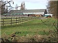
Running Well stables
This is Running Well Equestrian Centre. This consists of stables etc and 25 acres of land to keep horsey types happy.
Image: © Glyn Baker
Taken: 18 Feb 2006
0.21 miles
2
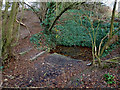
The Running Well
A new picture of the Running Well my gps gave its position as TQ75111 96579 with a 14 foot accuracy. I moved it slightly as that showed it on the bank.
This is purported to be the Holy Well or Sacred Spring that gave Runwell its name. There was no evidence of running while I was there.
Image: © terry joyce
Taken: 29 Dec 2011
0.21 miles
3
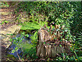
The Running Well
Photo of the holly spring near Runwell Essex
Image: © Simon
Taken: 12 Apr 2007
0.23 miles