IMAGES TAKEN NEAR TO
Old Church Road, CHELMSFORD, CM3 8BG
Introduction
This page details the photographs taken nearby to Old Church Road, CM3 8BG by members of the Geograph project.
The Geograph project started in 2005 with the aim of publishing, organising and preserving representative images for every square kilometre of Great Britain, Ireland and the Isle of Man.

There are currently over 7.5m images from over14,400 individuals and you can help contribute to the project by visiting https://www.geograph.org.uk
Image Map (Loading...)


Getting Data...Please wait
Leaflet Map data © OpenStreetMap
Images are licensed for reuse under creativecommons.org/licenses/by-sa/2.0
Notes
- Clicking on the map will re-center to the selected point.
- The higher the marker number, the further away the image location is from the centre of the postcode.
Image Listing (19 Images Found)
Images are licensed for reuse under creativecommons.org/licenses/by-sa/2.0
Image
Details
Distance
1
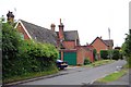
The Old School, East Hanningfield
The Old School - now a private house - is situated at the junction of Old Church Road and Back Lane. Most of it cannot be seen easily because of the boundary hedges. Here it is viewed from Back Lane. Obviously the garage is a more modern addition.
Image: © Trevor Harris
Taken: 9 Jun 2009
0.04 miles
2
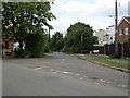
Back Lane, East Hanningfield
Junction of Back Lane with Old Church Road.
Image: © Roger Jones
Taken: 14 Jun 2011
0.05 miles
4
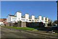
Houses on Catherine Close
One of several similar blocks on this estate. The view is of the back of the houses, the fronts of the elevated parts are just continuations of the roof line with uninterrupted tiling. Consequently the upper parts of the houses have no windows.
Image: © Robin Webster
Taken: 11 Dec 2012
0.10 miles
5
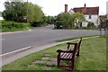
Seat & Rails Farm
At the junction of "The Tye", Main Rd and Old Church Lane
Image: © Glyn Baker
Taken: 14 May 2016
0.10 miles
6
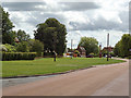
East Hanningfield Green
Looking along The Tye, East Hanningfield
Image: © Roger Jones
Taken: 18 Jun 2011
0.13 miles
7

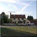
The Windmill, East Hanningfield
A C17 timber-framed house re-fronted in C18. See http://www.britishlistedbuildings.co.uk/en-112538-the-windmill-inn-east-hanningfield-essex for British Listed Building entry.
Image: © Bikeboy
Taken: 13 Sep 2014
0.14 miles
9
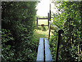
Footbridge and Stile, East Hanningfield
Public footpath, opposite Willis Farm, Main Road, East Hanningfield
Image: © Roger Jones
Taken: 18 Jun 2011
0.14 miles
10
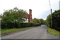
The Tye, East Hanningfield
The road is called The Tye. At its junction with Old Church Road stands the fine pargetted house seen here, with its magnificent chimneys.
Image: © Trevor Harris
Taken: 9 Jun 2009
0.15 miles