IMAGES TAKEN NEAR TO
Manor Way, CHELMSFORD, CM3 6YD
Introduction
This page details the photographs taken nearby to Manor Way, CM3 6YD by members of the Geograph project.
The Geograph project started in 2005 with the aim of publishing, organising and preserving representative images for every square kilometre of Great Britain, Ireland and the Isle of Man.

There are currently over 7.5m images from over14,400 individuals and you can help contribute to the project by visiting https://www.geograph.org.uk
Image Map
Images are licensed for reuse under creativecommons.org/licenses/by-sa/2.0
Notes
- Clicking on the map will re-center to the selected point.
- The higher the marker number, the further away the image location is from the centre of the postcode.
Image Listing (32 Images Found)
Images are licensed for reuse under creativecommons.org/licenses/by-sa/2.0
Image
Details
Distance
1
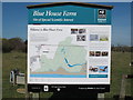
Blue House Farm Nature Reserve Information Board
Image: © Roger Jones
Taken: 27 Mar 2012
0.09 miles
2
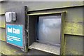
Owl Cam
A shadowy picture of a barn owl on The Essex Wildlife Trust
Image's Owl Cam
Image: © Glyn Baker
Taken: 7 May 2014
0.09 miles
3
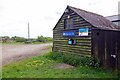
Roost on Blue House Farm
There are resident Barn Owls on Essex Wildlife Trust's Blue House Farm Nature Reserve http://www.essexwt.org.uk/reserves/blue-house-farm for proof see Image
Image: © Glyn Baker
Taken: 7 May 2014
0.09 miles
4
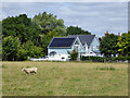
House, Bluehouse Farm Chase, North Fambridge
The last house except for the farmhouse.
Image: © Robin Webster
Taken: 4 Aug 2017
0.11 miles
6
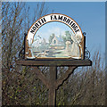
North Fambridge Village Sign
For close-up see Image]
Image: © Roger Jones
Taken: 27 Mar 2012
0.14 miles
7
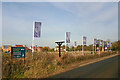
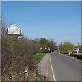
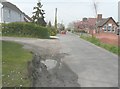
Land earmarked for building, North Fambridge
The flags suggest that the empty field behind them will soon be used to extend the Riverside Grange development, part of which can be seen in the background. The structure between the flag posts in the foreground once carried the village sign depicted in Image
Image: © David Kemp
Taken: 10 Feb 2023
0.15 miles
8
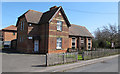
Old School House & Village Hall
The part of the building nearest us is The Old School House, which has been restored for use within the community thanks to a lottery grant. The section to the right is the Village hall.
Image: © Roger Jones
Taken: 1 Apr 2012
0.16 miles
9
Looking north along Ferry Road
River Cottage, dated 1902, is the grey-painted house on the left, while across the road is the village hall that dates from 1875.
Image: © John Baker
Taken: 3 Apr 2014
0.17 miles
10
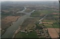
North Fambridge and River Crouch: aerial 2017
Image: © Chris
Taken: 25 Aug 2017
0.17 miles