IMAGES TAKEN NEAR TO
Imperial Avenue, CHELMSFORD, CM3 6TT
Introduction
This page details the photographs taken nearby to Imperial Avenue, CM3 6TT by members of the Geograph project.
The Geograph project started in 2005 with the aim of publishing, organising and preserving representative images for every square kilometre of Great Britain, Ireland and the Isle of Man.

There are currently over 7.5m images from over14,400 individuals and you can help contribute to the project by visiting https://www.geograph.org.uk
Image Map (Loading...)


Getting Data...Please wait
Leaflet Map data © OpenStreetMap
Images are licensed for reuse under creativecommons.org/licenses/by-sa/2.0
Notes
- Clicking on the map will re-center to the selected point.
- The higher the marker number, the further away the image location is from the centre of the postcode.
Image Listing (2 Images Found)
Images are licensed for reuse under creativecommons.org/licenses/by-sa/2.0
Image
Details
Distance
1
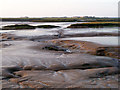
Evening mud, Mundon Creek
The main channels are formed by the low tide discharge from Lawling Hall 1 and 2 sluices.
Image: © Robin Webster
Taken: 1 Jun 2014
0.24 miles
2
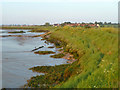
Sea wall, Mundon Creek
Looking towards Lawling Hall 2 sluice, with Maylandsea in the distance.
Image: © Robin Webster
Taken: 1 Jun 2014
0.25 miles