IMAGES TAKEN NEAR TO
Hackmans Lane, CHELMSFORD, CM3 6RN
Introduction
This page details the photographs taken nearby to Hackmans Lane, CM3 6RN by members of the Geograph project.
The Geograph project started in 2005 with the aim of publishing, organising and preserving representative images for every square kilometre of Great Britain, Ireland and the Isle of Man.

There are currently over 7.5m images from over14,400 individuals and you can help contribute to the project by visiting https://www.geograph.org.uk
Image Map (Loading...)


Getting Data...Please wait
Leaflet Map data © OpenStreetMap
Images are licensed for reuse under creativecommons.org/licenses/by-sa/2.0
Notes
- Clicking on the map will re-center to the selected point.
- The higher the marker number, the further away the image location is from the centre of the postcode.
Image Listing (5 Images Found)
Images are licensed for reuse under creativecommons.org/licenses/by-sa/2.0
Image
Details
Distance
1
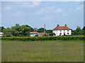
Flambird's Farm
On a private road off Hackmans Lane.
Image: © Robin Webster
Taken: 1 Jun 2014
0.00 miles
2
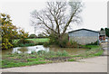
Flambird's Pond
This pond is by the entrance to Flambird's Farm.
Image: © terry joyce
Taken: 12 Nov 2010
0.04 miles
3
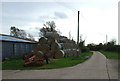
Straw Stack, Flambirds Chase
This straw stack is on Flambird's Farm. This is the access road to Stow Maries Aerodrome.
Image: © terry joyce
Taken: 12 Nov 2010
0.05 miles
4
Stow Maries Aerodrome
This is Flambirds Chase and just coming into sight is the entrance to Stow Maries Aerodrome.
Image: © terry joyce
Taken: 12 Nov 2010
0.14 miles
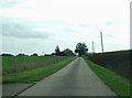
5
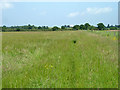
Footpath to Hackmans Lane
Following the field edge towards the water tower, as others have done before, is not quite the right way to go, as the stile into the next field is over to the left.
Image: © Robin Webster
Taken: 1 Jun 2014
0.23 miles