IMAGES TAKEN NEAR TO
Hackmans Lane, CHELMSFORD, CM3 6RJ
Introduction
This page details the photographs taken nearby to Hackmans Lane, CM3 6RJ by members of the Geograph project.
The Geograph project started in 2005 with the aim of publishing, organising and preserving representative images for every square kilometre of Great Britain, Ireland and the Isle of Man.

There are currently over 7.5m images from over14,400 individuals and you can help contribute to the project by visiting https://www.geograph.org.uk
Image Map
Images are licensed for reuse under creativecommons.org/licenses/by-sa/2.0
Notes
- Clicking on the map will re-center to the selected point.
- The higher the marker number, the further away the image location is from the centre of the postcode.
Image Listing (4 Images Found)
Images are licensed for reuse under creativecommons.org/licenses/by-sa/2.0
Image
Details
Distance
1
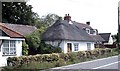
Thatched cottage, Cock Clarks
One of several in the village.
Image: © John Myers
Taken: 1 Sep 2006
0.17 miles
2
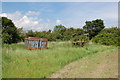
Rusting agricultural items by St Peter's Way
At the point the long distance path leaves Hackmans Lane going east.
Image: © Trevor Harris
Taken: 9 Jun 2014
0.19 miles
3
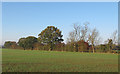
Bridleway by The Crib
The bridleway leads on to Charity Lane, or may already be Charity Lane at this point though there isn't much evidence of a track.
Image: © Trevor Harris
Taken: 9 Jun 2014
0.21 miles