IMAGES TAKEN NEAR TO
Spar Lane, CHELMSFORD, CM3 6QW
Introduction
This page details the photographs taken nearby to Spar Lane, CM3 6QW by members of the Geograph project.
The Geograph project started in 2005 with the aim of publishing, organising and preserving representative images for every square kilometre of Great Britain, Ireland and the Isle of Man.

There are currently over 7.5m images from over14,400 individuals and you can help contribute to the project by visiting https://www.geograph.org.uk
Image Map
Images are licensed for reuse under creativecommons.org/licenses/by-sa/2.0
Notes
- Clicking on the map will re-center to the selected point.
- The higher the marker number, the further away the image location is from the centre of the postcode.
Image Listing (4 Images Found)
Images are licensed for reuse under creativecommons.org/licenses/by-sa/2.0
Image
Details
Distance
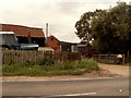
1
Spar Hill
Looking down the hill towards Rudley green
Image: © Glyn Baker
Taken: 28 Mar 2014
0.06 miles
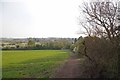
2
Bridleway and Spar Hill
Spar Lane is the bridle way from Rudley Green to Hazeleigh Hall Lane
Image: © Glyn Baker
Taken: 28 Mar 2014
0.11 miles
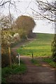
3
Footpath on farm track
Leading to Hazeleigh Hall Wood.
Image: © Roger Jones
Taken: 17 Dec 2011
0.18 miles