IMAGES TAKEN NEAR TO
Thornhill, CHELMSFORD, CM3 6PQ
Introduction
This page details the photographs taken nearby to Thornhill, CM3 6PQ by members of the Geograph project.
The Geograph project started in 2005 with the aim of publishing, organising and preserving representative images for every square kilometre of Great Britain, Ireland and the Isle of Man.

There are currently over 7.5m images from over14,400 individuals and you can help contribute to the project by visiting https://www.geograph.org.uk
Image Map (Loading...)


Getting Data...Please wait
Leaflet Map data © OpenStreetMap
Images are licensed for reuse under creativecommons.org/licenses/by-sa/2.0
Notes
- Clicking on the map will re-center to the selected point.
- The higher the marker number, the further away the image location is from the centre of the postcode.
Image Listing (20 Images Found)
Images are licensed for reuse under creativecommons.org/licenses/by-sa/2.0
Image
Details
Distance
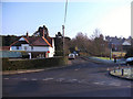
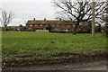
2
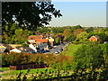
Road junction, Purleigh
The newer part of the village is down the road to the left, the older part down the minor road near right.
Image: © Robin Webster
Taken: 1 Jun 2014
0.09 miles
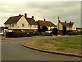
4
Green in Purleigh
Looking towards The Glebe opposite.
Image: © David Howard
Taken: 12 Mar 2023
0.10 miles
6
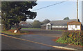
Purleigh village hall
Village notice board on right of picture.
Image: © Roger Jones
Taken: 20 Nov 2011
0.10 miles
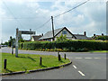
7
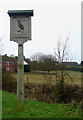
Purleigh Village Sign
Located on the grass verge opposite the Post Office.
Image: © terry joyce
Taken: 29 Dec 2009
0.11 miles
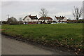
10
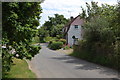
Howe Green Road
Taken from the green towards the northern end of the road near its junction with Mill Hill.
Image: © Trevor Harris
Taken: 9 Jun 2014
0.15 miles