IMAGES TAKEN NEAR TO
Rectory Road, CHELMSFORD, CM3 6NG
Introduction
This page details the photographs taken nearby to Rectory Road, CM3 6NG by members of the Geograph project.
The Geograph project started in 2005 with the aim of publishing, organising and preserving representative images for every square kilometre of Great Britain, Ireland and the Isle of Man.

There are currently over 7.5m images from over14,400 individuals and you can help contribute to the project by visiting https://www.geograph.org.uk
Image Map (Loading...)


Getting Data...Please wait
Leaflet Map data © OpenStreetMap
Images are licensed for reuse under creativecommons.org/licenses/by-sa/2.0
Notes
- Clicking on the map will re-center to the selected point.
- The higher the marker number, the further away the image location is from the centre of the postcode.
Image Listing (17 Images Found)
Images are licensed for reuse under creativecommons.org/licenses/by-sa/2.0
Image
Details
Distance
1
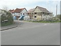
Erection of a house on plot 1 adjacent to 2 Rectory Road
Seen from Fambridge Road, the development of this site is described in Maldon District Council’s planning application 10/005918/FUL as the “erection of one dwelling”.
Image: © John Baker
Taken: 3 Apr 2014
0.06 miles
2
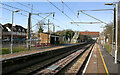
North Fambridge station
Taken looking in the up-direction towards Wickford. The line from Wickford to Southminster was opened in 1889 and electrified in 1986.
Image: © David Kemp
Taken: 10 Feb 2023
0.11 miles
3

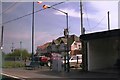
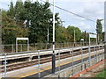
North Fambridge station - frontage
The entire station looks as though it was rebuilt around the time the line from Wickford to Southminster was electrified in 1986.
Image: © David Kemp
Taken: 10 Feb 2023
0.12 miles
4
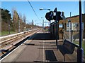
North Fambridge Station
Viewed from eastbound train on the Crouch Valley line, looking onto platform with car park and houses beyond.
Image: © Clint Mann
Taken: 21 Apr 2002
0.13 miles
5
North Fambridge Station
This is North Fambridge Station on the Crouch Valley line. This railway enabled the Dengie Peninsula from Southminster to South Woodham Ferrers to develop into London commuter land. The only reason this single track line (double in the stations) was allowed to escape the Beeching axe was its role in shipping plutonium to Aldermaston and spent fuel rods to Sellafield from the Image A fact the history of the line at http://www.esscrp.org.uk/crouch_valley_line/history/history.php seems to omit.
Photo was taken looking eastbound.
Image: © Glyn Baker
Taken: 25 Feb 2006
0.13 miles
6
Fambridge station, Essex
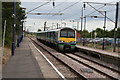
Great Eastern electric unit 321362 has just arrived from Southminster and will work the 14.34 up service onward to Wickford, after the arrival of the down service which it is scheduled to cross at this station.
Image: © Dr Neil Clifton
Taken: 11 Aug 2006
0.13 miles
7
Fambridge station, Essex (2)
Great Eastern electric unit 321313 enters Fambridge station on a down working to Southminster, passing as it does so 321362 on an up working to Wickford. Both trains are timed to leave Fambridge at 14.34
Image: © Dr Neil Clifton
Taken: 11 Aug 2006
0.13 miles
8
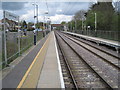
North Fambridge railway station, Essex
Opened in 1889 by the Great Eastern Railway on its line from Wickford to Southminster. View west towards South Woodham Ferrers and Wickford.
Image: © Nigel Thompson
Taken: 27 Apr 2013
0.13 miles
9
North Fambridge Station
North Fambridge Station is on the Crouch Valley line.
Image: © PAUL FARMER
Taken: 25 Sep 2011
0.15 miles
10

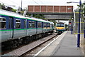
Fambridge Station
Southminster and Wickford-bound trains cross on the short section of double track through the station
Image: © John Myers
Taken: 12 Feb 2011
0.15 miles