IMAGES TAKEN NEAR TO
Roberts Road, CHELMSFORD, CM3 6LT
Introduction
This page details the photographs taken nearby to Roberts Road, CM3 6LT by members of the Geograph project.
The Geograph project started in 2005 with the aim of publishing, organising and preserving representative images for every square kilometre of Great Britain, Ireland and the Isle of Man.

There are currently over 7.5m images from over14,400 individuals and you can help contribute to the project by visiting https://www.geograph.org.uk
Image Map
Images are licensed for reuse under creativecommons.org/licenses/by-sa/2.0
Notes
- Clicking on the map will re-center to the selected point.
- The higher the marker number, the further away the image location is from the centre of the postcode.
Image Listing (34 Images Found)
Images are licensed for reuse under creativecommons.org/licenses/by-sa/2.0
Image
Details
Distance
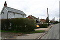
1
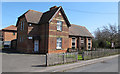
Old School House & Village Hall
The part of the building nearest us is The Old School House, which has been restored for use within the community thanks to a lottery grant. The section to the right is the Village hall.
Image: © Roger Jones
Taken: 1 Apr 2012
0.08 miles
2
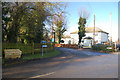
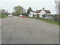
Junction of Ferry Road and Church Road
Looking from Ferry Road towards Church Road.
Image: © Trevor Harris
Taken: 30 Nov 2012
0.09 miles
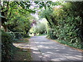
3
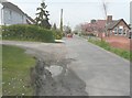
Looking north along Ferry Road
River Cottage, dated 1902, is the grey-painted house on the left, while across the road is the village hall that dates from 1875.
Image: © John Baker
Taken: 3 Apr 2014
0.09 miles
4
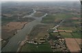
North Fambridge and River Crouch: aerial 2017
Image: © Chris
Taken: 25 Aug 2017
0.10 miles
5
Ferry Road, North Fambridge
Although this part of North Fambridge looks relatively unsuburban, housing development is now proceeding apace farther up Ferry Road.
Image: © David Kemp
Taken: 19 Mar 2023
0.12 miles
7
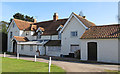
North Fambridge Hall
Listed building on Church Road: House, mainly c.1600, possibly of medieval origin, altered in C19.
List entry Number: 1110879 http://list.english-heritage.org.uk/resultsingle.aspx?uid=1110879
Image: © Roger Jones
Taken: 1 Apr 2012
0.17 miles
9
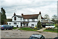
Ferry Boat Inn, North Fambridge
There is no longer a ferry to South Fambridge, but the inn survives.
Image: © Robin Webster
Taken: 4 Mar 2014
0.18 miles
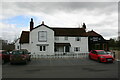
10
The Ferry Boat Inn, Ferry Road
It is a grade II listed building that dates from the 18th century but was altered in the 19th century. It was formerly a private house but is now a public house
http://www.britishlistedbuildings.co.uk/en-117408-the-ferry-boat-inn-north-fambridge-essex
Image: © John Baker
Taken: 3 Apr 2014
0.18 miles