IMAGES TAKEN NEAR TO
Maldon Road, CHELMSFORD, CM3 6LG
Introduction
This page details the photographs taken nearby to Maldon Road, CM3 6LG by members of the Geograph project.
The Geograph project started in 2005 with the aim of publishing, organising and preserving representative images for every square kilometre of Great Britain, Ireland and the Isle of Man.

There are currently over 7.5m images from over14,400 individuals and you can help contribute to the project by visiting https://www.geograph.org.uk
Image Map
Images are licensed for reuse under creativecommons.org/licenses/by-sa/2.0
Notes
- Clicking on the map will re-center to the selected point.
- The higher the marker number, the further away the image location is from the centre of the postcode.
Image Listing (3 Images Found)
Images are licensed for reuse under creativecommons.org/licenses/by-sa/2.0
Image
Details
Distance
1
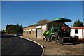
Workshop
The building is a car repair workshop on an industrial estate between Mundon and Latchingdon. The roads were in the process of being resurfaced.
Image: © Glyn Baker
Taken: 19 Nov 2006
0.03 miles
2
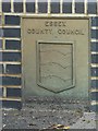
Old Boundary Marker
Bridge Marker on east bridge parapet of Deadaway Bridge, Maldon Road. On boundary of Latchingdon and Mundon parishes. ESSEX COUNTY / COUNCIL / (coat of arms) / DEADAWAY BRIDGE / 1923 in raised lettering.
Milestone Society National ID: EX_LATMUN01br
Image: © M Bardell
Taken: 29 Oct 2019
0.10 miles
3

Industrial Units in Latchingdon
Autumn colours can even brighten up the most mundane industrial buildings. These are on the Mayfair Industrial Estate.
Image: © Glyn Baker
Taken: 19 Nov 2006
0.18 miles