IMAGES TAKEN NEAR TO
St. Stephens Road, CHELMSFORD, CM3 6JE
Introduction
This page details the photographs taken nearby to St. Stephens Road, CM3 6JE by members of the Geograph project.
The Geograph project started in 2005 with the aim of publishing, organising and preserving representative images for every square kilometre of Great Britain, Ireland and the Isle of Man.

There are currently over 7.5m images from over14,400 individuals and you can help contribute to the project by visiting https://www.geograph.org.uk
Image Map (Loading...)


Getting Data...Please wait
Leaflet Map data © OpenStreetMap
Images are licensed for reuse under creativecommons.org/licenses/by-sa/2.0
Notes
- Clicking on the map will re-center to the selected point.
- The higher the marker number, the further away the image location is from the centre of the postcode.
Image Listing (15 Images Found)
Images are licensed for reuse under creativecommons.org/licenses/by-sa/2.0
Image
Details
Distance
2
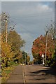
St. Stephens Road
Just beyond the traffic signs is the top of a railway bridge that crosses a disused line.
Image: © Robert Edwards
Taken: 7 Apr 2008
0.13 miles
3
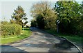
Bridge over former railway, Cold Norton
The line was the Woodham Ferrers - Maldon link, which never did very well. Opened in 1889, it closed to passengers during WWII and to freight in 1953. The cutting under the bridge is largely filled in. This bridge is still stencilled with railway reference number WFM-839, which seems a very high number for a short line - about 8 miles.
Image: © Robin Webster
Taken: 4 Mar 2014
0.13 miles
4
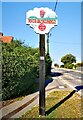
The village sign in Cold Norton
Came across this while out geocaching on the Dengie. There's a geocache nearby, in case anyone's into that.
Image: © Paul Jones
Taken: 20 Sep 2020
0.15 miles
5
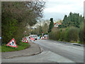
Temporary traffic lights, Cold Norton
By the Norton pub on the right, which seems to have reopened after a period of closure.
Image: © Robin Webster
Taken: 4 Mar 2014
0.15 miles
6
Cold Norton
A Zebra Crossing on the Latchingdon Rd
Image: © Glyn Baker
Taken: 12 May 2016
0.16 miles
7
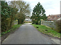
'The Norton', Cold Norton
The only pub I know of with a name that celebrates an old 'British bike'. Maybe somewhere there's a 'Matchless', or an 'Ariel Square Four', or a 'Black Shadow'.
But - to return to the photograph: beyond the pub the road narrows - crossing a bridge over an old railway cutting. The railway has long since gone, closed even before the Beeching era. I suppose the village chose to keep the narrow bridge to slow down the traffic.
Here's the pub sign: http://www.geograph.org.uk/photo/4995711
Image: © Stefan Czapski
Taken: 11 Jun 2016
0.16 miles
8
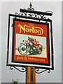
Pub sign: 'The Norton', Cold Norton
Good to see a pub that commemorates an old British motor-bike. My Dad would have chuckled, though the bike he kept in the garage into his old age was a Royal Enfield.
Image: © Stefan Czapski
Taken: 11 Jun 2016
0.16 miles
9
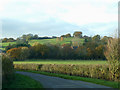
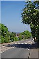
View from St Stephens Road
Taken from St Stephens Road, looking across this grid and into Image
Some of Three Rivers Golf Course can be seen.
Image: © terry joyce
Taken: 24 Nov 2010
0.16 miles
10
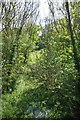
Forget me nots on the Forgotten railway
The permanent way does not look so permanent now. The Maldon to Woodham Ferrers line finally closed to goods traffic in 1953.
Image: © Glyn Baker
Taken: 12 May 2016
0.17 miles