IMAGES TAKEN NEAR TO
Lordship Way, CM3 6FW
Introduction
This page details the photographs taken nearby to Lordship Way, CM3 6FW by members of the Geograph project.
The Geograph project started in 2005 with the aim of publishing, organising and preserving representative images for every square kilometre of Great Britain, Ireland and the Isle of Man.

There are currently over 7.5m images from over14,400 individuals and you can help contribute to the project by visiting https://www.geograph.org.uk
Image Map
Images are licensed for reuse under creativecommons.org/licenses/by-sa/2.0
Notes
- Clicking on the map will re-center to the selected point.
- The higher the marker number, the further away the image location is from the centre of the postcode.
Image Listing (17 Images Found)
Images are licensed for reuse under creativecommons.org/licenses/by-sa/2.0
Image
Details
Distance
1
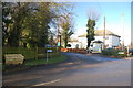
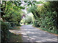
Junction of Ferry Road and Church Road
Looking from Ferry Road towards Church Road.
Image: © Trevor Harris
Taken: 30 Nov 2012
0.13 miles
2
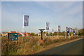
Land earmarked for building, North Fambridge
The flags suggest that the empty field behind them will soon be used to extend the Riverside Grange development, part of which can be seen in the background. The structure between the flag posts in the foreground once carried the village sign depicted in Image
Image: © David Kemp
Taken: 10 Feb 2023
0.13 miles
4
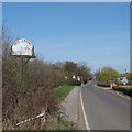
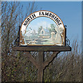
North Fambridge Village Sign
For close-up see Image]
Image: © Roger Jones
Taken: 27 Mar 2012
0.14 miles
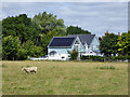
5
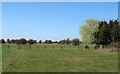
Lone horse
A solitary horse in one of a number of paddocks, just off Fambridge Road.
Image: © Roger Jones
Taken: 27 Mar 2012
0.17 miles
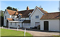
6
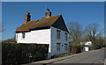
Smugglers Cottage
Note the double roof.
According to the Smugglers’ Britain website http://www.smuggling.co.uk/gazetteer_e_11.html regarding North Fambridge: "... smugglers' tunnels used to run to Blue Farm and Smugglers' cottage (sic) nearby."
Image: © Roger Jones
Taken: 27 Mar 2012
0.17 miles
8
House, Bluehouse Farm Chase, North Fambridge
The last house except for the farmhouse.
Image: © Robin Webster
Taken: 4 Aug 2017
0.18 miles
9
North Fambridge Hall
Listed building on Church Road: House, mainly c.1600, possibly of medieval origin, altered in C19.
List entry Number: 1110879 http://list.english-heritage.org.uk/resultsingle.aspx?uid=1110879
Image: © Roger Jones
Taken: 1 Apr 2012
0.21 miles