IMAGES TAKEN NEAR TO
Burnham Road, CHELMSFORD, CM3 6EZ
Introduction
This page details the photographs taken nearby to Burnham Road, CM3 6EZ by members of the Geograph project.
The Geograph project started in 2005 with the aim of publishing, organising and preserving representative images for every square kilometre of Great Britain, Ireland and the Isle of Man.

There are currently over 7.5m images from over14,400 individuals and you can help contribute to the project by visiting https://www.geograph.org.uk
Image Map (Loading...)


Getting Data...Please wait
Leaflet Map data © OpenStreetMap
Images are licensed for reuse under creativecommons.org/licenses/by-sa/2.0
Notes
- Clicking on the map will re-center to the selected point.
- The higher the marker number, the further away the image location is from the centre of the postcode.
Image Listing (3 Images Found)
Images are licensed for reuse under creativecommons.org/licenses/by-sa/2.0
Image
Details
Distance
1
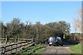
Track near Meadow View Farm
Early blackthorn (sloe) flowers in the hedge ahead.
Image: © Trevor Harris
Taken: 25 Feb 2022
0.06 miles
3
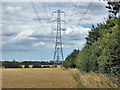
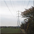
Power line over a barley field
This leads to the decommissioned Bradwell nuclear power station.
Image: © Robin Webster
Taken: 4 Aug 2017
0.23 miles