IMAGES TAKEN NEAR TO
Bulbecks Walk, CHELMSFORD, CM3 5ZN
Introduction
This page details the photographs taken nearby to Bulbecks Walk, CM3 5ZN by members of the Geograph project.
The Geograph project started in 2005 with the aim of publishing, organising and preserving representative images for every square kilometre of Great Britain, Ireland and the Isle of Man.

There are currently over 7.5m images from over14,400 individuals and you can help contribute to the project by visiting https://www.geograph.org.uk
Image Map (Loading...)


Getting Data...Please wait
Leaflet Map data © OpenStreetMap
Images are licensed for reuse under creativecommons.org/licenses/by-sa/2.0
Notes
- Clicking on the map will re-center to the selected point.
- The higher the marker number, the further away the image location is from the centre of the postcode.
Image Listing (7 Images Found)
Images are licensed for reuse under creativecommons.org/licenses/by-sa/2.0
Image
Details
Distance
1
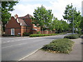
South Woodham Ferrers: Inchbonnie Road
The estate road leading off to the left is Drywoods. The street trees are London Planes.
Image: © Nigel Cox
Taken: 15 Aug 2006
0.14 miles
2
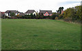
Frankland Fields
Open space which is part of a developing nature reserve.
Image: © Roger Jones
Taken: 2 Nov 2011
0.16 miles
3
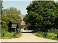
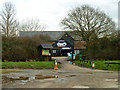
The approach to the visitor centre at Marsh Farm Country Park
The country park lies to the south of South Woodham Ferrers, by the River Crouch. This is the view from the car park.
Image: © Robert Edwards
Taken: 21 May 2008
0.20 miles
4
Marsh Farm Country Park, South Woodham Ferrers
We had a good day out here - see http://marshfarmcountrypark.co.uk for more information.
Image: © Andy Potter
Taken: 3 Aug 2002
0.20 miles
5
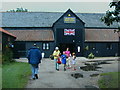
Entrance, Marsh Farm Animal Adventure Park
Part of Marsh Farm Country Park.
Image: © Robin Webster
Taken: 4 Mar 2014
0.21 miles
6
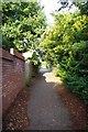
Cycleway to Collingwood Rd
S Woodham Ferrers is well supplied with cycle paths
Image: © Glyn Baker
Taken: 30 Aug 2013
0.22 miles
7
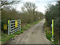
Private road to yacht club
This road to South Woodham Ferrers Yacht Club is parallel to the public road to the river bank.
Image: © Robin Webster
Taken: 4 Mar 2014
0.22 miles