IMAGES TAKEN NEAR TO
Beatty Rise, CHELMSFORD, CM3 5YQ
Introduction
This page details the photographs taken nearby to Beatty Rise, CM3 5YQ by members of the Geograph project.
The Geograph project started in 2005 with the aim of publishing, organising and preserving representative images for every square kilometre of Great Britain, Ireland and the Isle of Man.

There are currently over 7.5m images from over14,400 individuals and you can help contribute to the project by visiting https://www.geograph.org.uk
Image Map
Images are licensed for reuse under creativecommons.org/licenses/by-sa/2.0
Notes
- Clicking on the map will re-center to the selected point.
- The higher the marker number, the further away the image location is from the centre of the postcode.
Image Listing (11 Images Found)
Images are licensed for reuse under creativecommons.org/licenses/by-sa/2.0
Image
Details
Distance
1
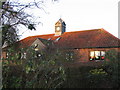
Collingwood Primary School
One of 6 primary schools in South Woodham Ferrers
Image: © Angela Tuff
Taken: 21 Jan 2006
0.14 miles
4
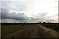
Sea wall west of Clementsgreen Creek
Looking along the sea wall path.
Image: © Trevor Harris
Taken: 29 Aug 2014
0.19 miles
5
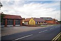
999 (Town Planners Delight)
Where else but in a new town would you find all four first responders in a line? fire, ambulance & police stations all next door. The coastguard office is out of shot to the left. This is Ferrers Rd in South Woodham Ferrers
Image: © Glyn Baker
Taken: 30 Aug 2013
0.20 miles
6
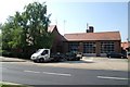
South Woodham Ferrers fire station
South Woodham Ferrers fire station, Ferrers Road, South Woodham Ferrers, Chelmsford, Essex
Image: © Kevin Hale
Taken: 4 Jun 2010
0.21 miles
7
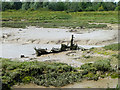
Boat skeleton, Clementsgreen Creek
The sternpost is prominent, suggesting a sailing vessel, but a close look shows there is still an engine in place, offset to the far side, so presumably an auxiliary. So it is not as ancient as it looks. Crew aboard is a crow.
Image: © Robin Webster
Taken: 21 Jun 2014
0.22 miles
8
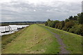
Marsh Farm Country Park
Part of the marsh that gave the park its name. The shot was taken looking north.
Image: © Glyn Baker
Taken: 25 Feb 2006
0.23 miles
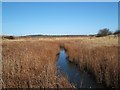
9

Reed-choked Dyke
Wild area to the south of Compass Gardens
Image: © John Myers
Taken: 14 Sep 2011
0.23 miles
10
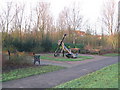
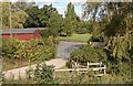
Compass Gardens
Compass Gardens is based upon a nautical theme. The central paving area of the park is marked out as a large compass displaying the latitude and longitude of the park.
Image: © Angela Tuff
Taken: 21 Jan 2006
0.24 miles