IMAGES TAKEN NEAR TO
Redhills Road, CHELMSFORD, CM3 5UL
Introduction
This page details the photographs taken nearby to Redhills Road, CM3 5UL by members of the Geograph project.
The Geograph project started in 2005 with the aim of publishing, organising and preserving representative images for every square kilometre of Great Britain, Ireland and the Isle of Man.

There are currently over 7.5m images from over14,400 individuals and you can help contribute to the project by visiting https://www.geograph.org.uk
Image Map
Images are licensed for reuse under creativecommons.org/licenses/by-sa/2.0
Notes
- Clicking on the map will re-center to the selected point.
- The higher the marker number, the further away the image location is from the centre of the postcode.
Image Listing (6 Images Found)
Images are licensed for reuse under creativecommons.org/licenses/by-sa/2.0
Image
Details
Distance
2
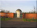
Garden of Remembrance
Situated on the oitskirts of South Woodham Ferrers. Provided by the Town Council.
Image: © Angela Tuff
Taken: 21 Jan 2006
0.13 miles
5
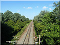
Southminster branch east of Woodham Ferrers
A whistle sign precedes a farm accommodation crossing.
Image: © Robin Webster
Taken: 21 Jun 2014
0.24 miles
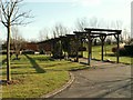
6
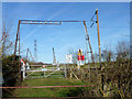
The Bells
This is a railway crossing for Farm vehicles and it has a set of bells to warn the driver if the vehicle is loaded too high.
Image: © terry joyce
Taken: 6 Jan 2012
0.25 miles