IMAGES TAKEN NEAR TO
The Bight, CHELMSFORD, CM3 5GJ
Introduction
This page details the photographs taken nearby to The Bight, CM3 5GJ by members of the Geograph project.
The Geograph project started in 2005 with the aim of publishing, organising and preserving representative images for every square kilometre of Great Britain, Ireland and the Isle of Man.

There are currently over 7.5m images from over14,400 individuals and you can help contribute to the project by visiting https://www.geograph.org.uk
Image Map (Loading...)


Getting Data...Please wait
Leaflet Map data © OpenStreetMap
Images are licensed for reuse under creativecommons.org/licenses/by-sa/2.0
Notes
- Clicking on the map will re-center to the selected point.
- The higher the marker number, the further away the image location is from the centre of the postcode.
Image Listing (4 Images Found)
Images are licensed for reuse under creativecommons.org/licenses/by-sa/2.0
Image
Details
Distance
1
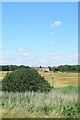
Marshland between the Crouch and the southern edge of South Woodham Ferrers
Image: © John Myers
Taken: 4 Jul 2022
0.11 miles
2
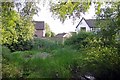
Pond in South Woodham Ferrers
Looking across a rather overgrown pond towards houses in Blackwood Chine
Image: © Glyn Baker
Taken: 30 Aug 2013
0.16 miles
3
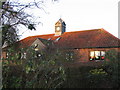
Collingwood Primary School
One of 6 primary schools in South Woodham Ferrers
Image: © Angela Tuff
Taken: 21 Jan 2006
0.19 miles
4
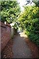
Cycleway to Collingwood Rd
S Woodham Ferrers is well supplied with cycle paths
Image: © Glyn Baker
Taken: 30 Aug 2013
0.23 miles