IMAGES TAKEN NEAR TO
The Ridge, CHELMSFORD, CM3 4SX
Introduction
This page details the photographs taken nearby to The Ridge, CM3 4SX by members of the Geograph project.
The Geograph project started in 2005 with the aim of publishing, organising and preserving representative images for every square kilometre of Great Britain, Ireland and the Isle of Man.

There are currently over 7.5m images from over14,400 individuals and you can help contribute to the project by visiting https://www.geograph.org.uk
Image Map (Loading...)


Getting Data...Please wait
Leaflet Map data © OpenStreetMap
Images are licensed for reuse under creativecommons.org/licenses/by-sa/2.0
Notes
- Clicking on the map will re-center to the selected point.
- The higher the marker number, the further away the image location is from the centre of the postcode.
Image Listing (13 Images Found)
Images are licensed for reuse under creativecommons.org/licenses/by-sa/2.0
Image
Details
Distance
1
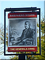
The Generals Arms - inn sign
For a view of the pub, see Image
Image: © Robin Webster
Taken: 11 Dec 2012
0.04 miles
2
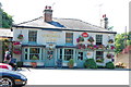
The Generals Arm, Little Baddow
A Shepherd Neame pub.
Image: © Trevor Harris
Taken: 1 Aug 2013
0.04 miles
3
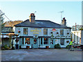
The Generals Arms, Little Baddow
A Shepherd Neame house.
Image: © Robin Webster
Taken: 11 Dec 2012
0.04 miles
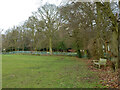
4
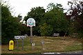
Little Baddow
Little Baddow Village Green the tree in the background was planted to commemorate the 50th anniversary of the end of the second world war.
Image: © Glyn Baker
Taken: 6 Aug 2006
0.08 miles
5
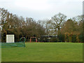
Swings and nets, Little Baddow Sports Field
Principally a cricket ground.
Image: © Robin Webster
Taken: 8 Dec 2012
0.12 miles
7
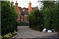
The Old Rectory
This is the Old Rectory in Little Baddow, The Rectory is a 1960’s building a few yards further down the road.
Image: © Glyn Baker
Taken: 6 Aug 2006
0.16 miles
8
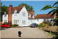
The Old Rodney
Now a private house - which was its original function when it was known as Warren House. By 1777 it had become an ale house originally known as The Cock and Warren. Later renamed The Rodney, it became The Old Rodney when the name was used by the present pub lower down the hill in Little Baddow. Later it became a tearoom and hotel before reverting to a private house in 1948. http://www.pubshistory.com/EssexPubs/LittleBaddow/oldrod.shtml
Image: © Trevor Harris
Taken: 1 Aug 2013
0.20 miles
9
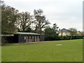
Pavilion, Little Baddow Sports Field
The ground is used principally for cricket.
Image: © Robin Webster
Taken: 8 Dec 2012
0.21 miles
10
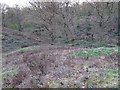
Heather Hills Nature Reserve, Little Baddow
This reserve is managed by Essex Wildlife Trust and owned by Little Baddow Parish Council, see http://www.wildessex.net/sites/Heather%20Hills.htm & http://www.littlebaddow.org.uk/heather_hills.asp
This picture shows the heather on the slopes which gives the area its name.
Image: © Roger Jones
Taken: 27 Apr 2013
0.22 miles