IMAGES TAKEN NEAR TO
Postmans Lane, CHELMSFORD, CM3 4SF
Introduction
This page details the photographs taken nearby to Postmans Lane, CM3 4SF by members of the Geograph project.
The Geograph project started in 2005 with the aim of publishing, organising and preserving representative images for every square kilometre of Great Britain, Ireland and the Isle of Man.

There are currently over 7.5m images from over14,400 individuals and you can help contribute to the project by visiting https://www.geograph.org.uk
Image Map
Images are licensed for reuse under creativecommons.org/licenses/by-sa/2.0
Notes
- Clicking on the map will re-center to the selected point.
- The higher the marker number, the further away the image location is from the centre of the postcode.
Image Listing (4 Images Found)
Images are licensed for reuse under creativecommons.org/licenses/by-sa/2.0
Image
Details
Distance
1
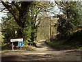
Public bridleway through Pheasanthouse Wood
This first section leads to somes houses and it's known as Postmans Lane.
Image: © Robert Edwards
Taken: 21 Mar 2008
0.13 miles
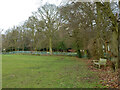
2
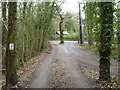
Way out from sports field, Little Baddow
To Riffhams Chase.
Image: © Robin Webster
Taken: 8 Dec 2012
0.24 miles
3
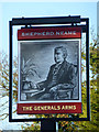
The Generals Arms - inn sign
For a view of the pub, see Image
Image: © Robin Webster
Taken: 11 Dec 2012
0.24 miles