IMAGES TAKEN NEAR TO
Dockwra Lane, CHELMSFORD, CM3 4RQ
Introduction
This page details the photographs taken nearby to Dockwra Lane, CM3 4RQ by members of the Geograph project.
The Geograph project started in 2005 with the aim of publishing, organising and preserving representative images for every square kilometre of Great Britain, Ireland and the Isle of Man.

There are currently over 7.5m images from over14,400 individuals and you can help contribute to the project by visiting https://www.geograph.org.uk
Image Map
Images are licensed for reuse under creativecommons.org/licenses/by-sa/2.0
Notes
- Clicking on the map will re-center to the selected point.
- The higher the marker number, the further away the image location is from the centre of the postcode.
Image Listing (4 Images Found)
Images are licensed for reuse under creativecommons.org/licenses/by-sa/2.0
Image
Details
Distance
1
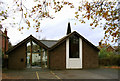
Church of the English Martyrs, Danbury, Essex
Roman Catholic.
Image: © Peter Stack
Taken: 24 Nov 2009
0.13 miles
2
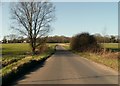
Runsell Lane, looking towards Danbury
Image: © Robert Edwards
Taken: 11 Feb 2008
0.14 miles
3
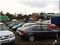
British Legion Pit - Danbury
The British Legion pit or more formally the British Legion Business Park is a small industrial estate just off the A414 Maldon Road.
At the time of this photograph it was home to two auto repairs, two engineering companies and a plant hire company.
Image: © Malcolm Reid
Taken: 9 Jan 2007
0.24 miles
4
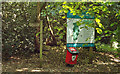
Trail Begins
Coming in from Image], if you bear right you will see the information board, map and signpost. Follow the direction of the signpost to get to Image
Image: © Roger Jones
Taken: 4 Jun 2011
0.25 miles